You are here: Home > Network List > TA - USArray Transportable Network (new EarthScope stations) Stations List
> Station M24K Tolsona, Glennallen, AK, USA > Earthquake Result Viewer
M24K Tolsona, Glennallen, AK, USA - Earthquake Result Viewer
| Earthquake location: |
Northern Molucca Sea |
| Earthquake latitude/longitude: |
1.9/126.5 |
| Earthquake time(UTC): |
2014/11/26 (330) 15:02:48 GMT |
| Earthquake Depth: |
47 km |
| Earthquake Magnitude: |
5.0 mb, 5.0 mb |
| Earthquake Catalog/Contributor: |
ISC/ISC |
|
| Network: |
TA USArray Transportable Network (new EarthScope stations) |
| Station: |
M24K Tolsona, Glennallen, AK, USA |
| Lat/Lon: |
62.11 N/146.18 W |
| Elevation: |
908 m |
|
| Distance: |
87.1 deg |
| Az: |
28.059 deg |
| Baz: |
268.513 deg |
| Ray Param: |
0.04349031 |
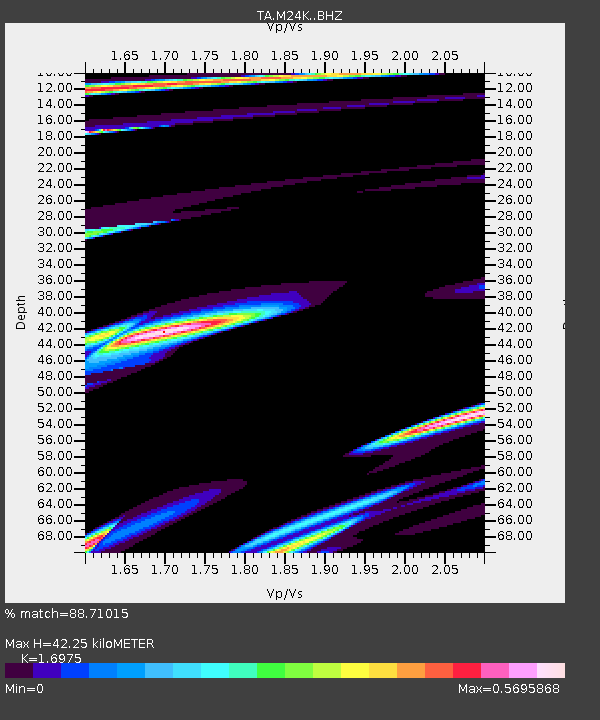
| Estimated Moho Depth: |
42.25 km |
| Estimated Crust Vp/Vs: |
1.70 |
| Assumed Crust Vp: |
6.566 km/s |
| Estimated Crust Vs: |
3.868 km/s |
| Estimated Crust Poisson's Ratio: |
0.23 |
|
| Radial Match: |
88.71015 % |
| Radial Bump: |
400 |
| Transverse Match: |
50.22375 % |
| Transverse Bump: |
373 |
| SOD ConfigId: |
3390531 |
| Insert Time: |
2019-04-15 05:09:32.815 +0000 |
| GWidth: |
2.5 |
| Max Bumps: |
400 |
| Tol: |
0.001 |
|
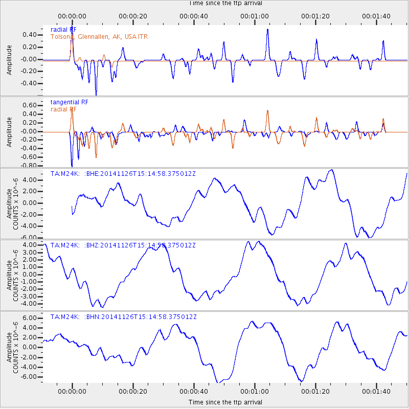
Signal To Noise
| Channel | StoN | STA | LTA |
| TA:M24K: :BHZ:20141126T15:14:58.375012Z | 0.47488263 | 1.2005564E-6 | 2.5281117E-6 |
| TA:M24K: :BHN:20141126T15:14:58.375012Z | 0.9009611 | 1.1606109E-6 | 1.2881919E-6 |
| TA:M24K: :BHE:20141126T15:14:58.375012Z | 3.291507 | 4.0734426E-6 | 1.2375616E-6 |
| Arrivals |
| Ps | 4.6 SECOND |
| PpPs | 17 SECOND |
| PsPs/PpSs | 22 SECOND |


