You are here: Home > Network List > US - United States National Seismic Network Stations List
> Station MNTX Cornudas Mountains, Texas, USA > Earthquake Result Viewer
MNTX Cornudas Mountains, Texas, USA - Earthquake Result Viewer
| Earthquake location: |
Near Coast Of Peru |
| Earthquake latitude/longitude: |
-15.8/-74.5 |
| Earthquake time(UTC): |
2013/09/25 (268) 16:42:43 GMT |
| Earthquake Depth: |
40 km |
| Earthquake Magnitude: |
7.1 MWW, 6.8 MI, 7.0 MWB, 7.0 MWC, 7.1 MWW, 7.1 MWC |
| Earthquake Catalog/Contributor: |
NEIC PDE/NEIC COMCAT |
|
| Network: |
US United States National Seismic Network |
| Station: |
MNTX Cornudas Mountains, Texas, USA |
| Lat/Lon: |
31.70 N/105.38 W |
| Elevation: |
404 m |
|
| Distance: |
55.8 deg |
| Az: |
328.066 deg |
| Baz: |
143.325 deg |
| Ray Param: |
0.064488135 |
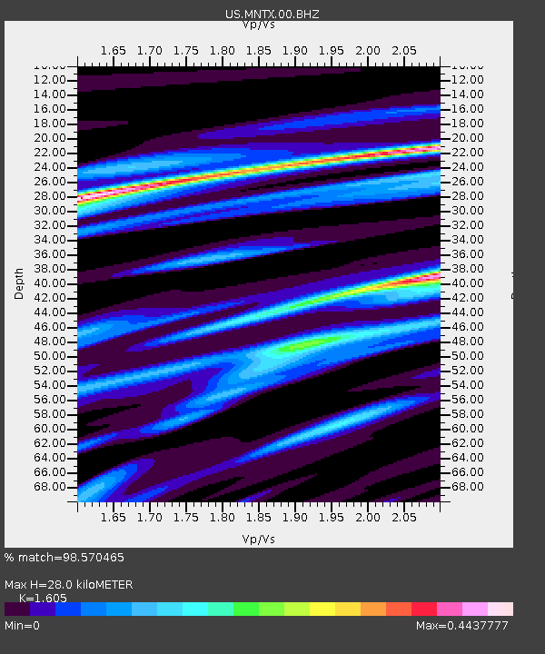
| Estimated Moho Depth: |
28.0 km |
| Estimated Crust Vp/Vs: |
1.61 |
| Assumed Crust Vp: |
6.361 km/s |
| Estimated Crust Vs: |
3.963 km/s |
| Estimated Crust Poisson's Ratio: |
0.18 |
|
| Radial Match: |
98.570465 % |
| Radial Bump: |
224 |
| Transverse Match: |
90.07125 % |
| Transverse Bump: |
275 |
| SOD ConfigId: |
626651 |
| Insert Time: |
2014-04-18 20:53:51.654 +0000 |
| GWidth: |
2.5 |
| Max Bumps: |
400 |
| Tol: |
0.001 |
|

Signal To Noise
| Channel | StoN | STA | LTA |
| US:MNTX:00:BHZ:20130925T16:51:45.474993Z | 35.979893 | 5.569927E-6 | 1.5480666E-7 |
| US:MNTX:00:BH1:20130925T16:51:45.474993Z | 19.488514 | 2.4697936E-6 | 1.2673073E-7 |
| US:MNTX:00:BH2:20130925T16:51:45.474993Z | 3.9356456 | 6.5071737E-7 | 1.6533943E-7 |
| Arrivals |
| Ps | 2.8 SECOND |
| PpPs | 11 SECOND |
| PsPs/PpSs | 14 SECOND |


