You are here: Home > Network List > US - United States National Seismic Network Stations List
> Station WRAK Wrangell Island, Southeastern Alaska, Alaska, USA > Earthquake Result Viewer
WRAK Wrangell Island, Southeastern Alaska, Alaska, USA - Earthquake Result Viewer
| Earthquake location: |
Near Coast Of Peru |
| Earthquake latitude/longitude: |
-15.8/-74.5 |
| Earthquake time(UTC): |
2013/09/25 (268) 16:42:43 GMT |
| Earthquake Depth: |
40 km |
| Earthquake Magnitude: |
7.1 MWW, 6.8 MI, 7.0 MWB, 7.0 MWC, 7.1 MWW, 7.1 MWC |
| Earthquake Catalog/Contributor: |
NEIC PDE/NEIC COMCAT |
|
| Network: |
US United States National Seismic Network |
| Station: |
WRAK Wrangell Island, Southeastern Alaska, Alaska, USA |
| Lat/Lon: |
56.42 N/132.35 W |
| Elevation: |
81 m |
|
| Distance: |
86.6 deg |
| Az: |
331.886 deg |
| Baz: |
125.292 deg |
| Ray Param: |
0.04387175 |
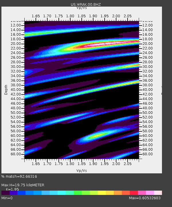
| Estimated Moho Depth: |
19.75 km |
| Estimated Crust Vp/Vs: |
1.95 |
| Assumed Crust Vp: |
6.597 km/s |
| Estimated Crust Vs: |
3.383 km/s |
| Estimated Crust Poisson's Ratio: |
0.32 |
|
| Radial Match: |
92.66316 % |
| Radial Bump: |
400 |
| Transverse Match: |
87.93439 % |
| Transverse Bump: |
400 |
| SOD ConfigId: |
626651 |
| Insert Time: |
2014-04-18 20:54:37.682 +0000 |
| GWidth: |
2.5 |
| Max Bumps: |
400 |
| Tol: |
0.001 |
|
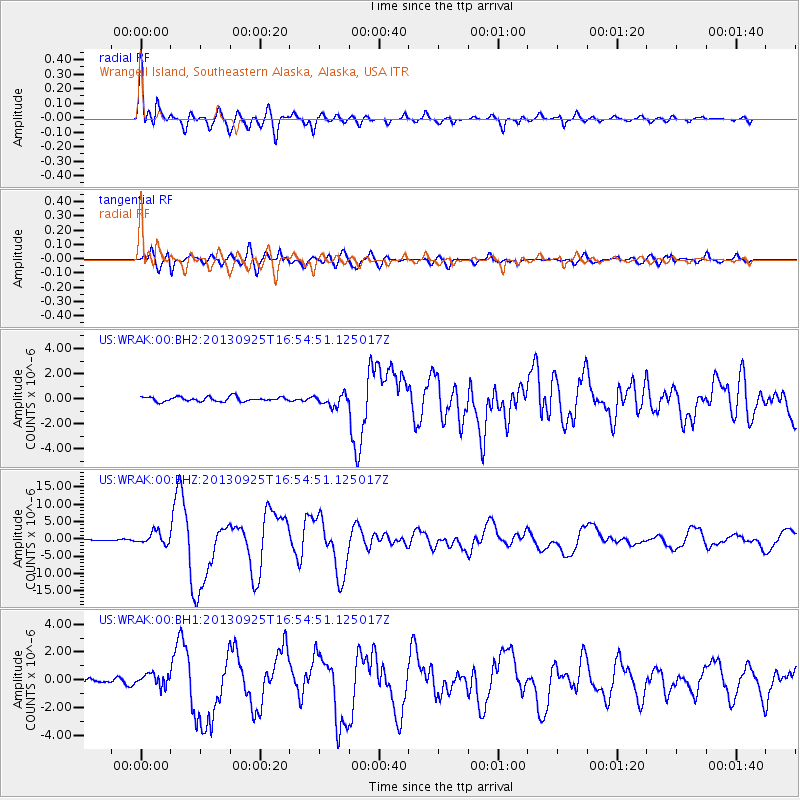
Signal To Noise
| Channel | StoN | STA | LTA |
| US:WRAK:00:BHZ:20130925T16:54:51.125017Z | 6.6733975 | 1.7601592E-6 | 2.6375758E-7 |
| US:WRAK:00:BH1:20130925T16:54:51.125017Z | 2.1965106 | 4.4209366E-7 | 2.012709E-7 |
| US:WRAK:00:BH2:20130925T16:54:51.125017Z | 2.5297751 | 4.5110076E-7 | 1.7831654E-7 |
| Arrivals |
| Ps | 2.9 SECOND |
| PpPs | 8.6 SECOND |
| PsPs/PpSs | 12 SECOND |


