You are here: Home > Network List > UU - University of Utah Regional Network Stations List
> Station CCUT Cedar City, UT, USA > Earthquake Result Viewer
CCUT Cedar City, UT, USA - Earthquake Result Viewer
| Earthquake location: |
Near Coast Of Peru |
| Earthquake latitude/longitude: |
-15.8/-74.5 |
| Earthquake time(UTC): |
2013/09/25 (268) 16:42:43 GMT |
| Earthquake Depth: |
40 km |
| Earthquake Magnitude: |
7.1 MWW, 6.8 MI, 7.0 MWB, 7.0 MWC, 7.1 MWW, 7.1 MWC |
| Earthquake Catalog/Contributor: |
NEIC PDE/NEIC COMCAT |
|
| Network: |
UU University of Utah Regional Network |
| Station: |
CCUT Cedar City, UT, USA |
| Lat/Lon: |
37.55 N/113.36 W |
| Elevation: |
2127 m |
|
| Distance: |
64.5 deg |
| Az: |
326.456 deg |
| Baz: |
137.996 deg |
| Ray Param: |
0.058835406 |
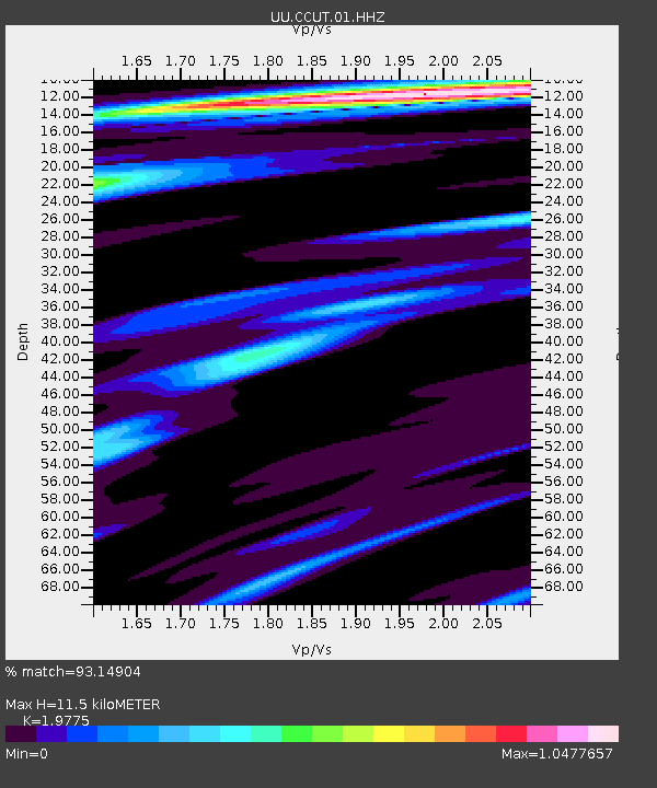
| Estimated Moho Depth: |
11.5 km |
| Estimated Crust Vp/Vs: |
1.98 |
| Assumed Crust Vp: |
6.194 km/s |
| Estimated Crust Vs: |
3.132 km/s |
| Estimated Crust Poisson's Ratio: |
0.33 |
|
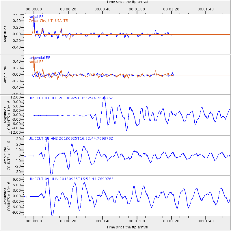
| Radial Match: |
93.14904 % |
| Radial Bump: |
245 |
| Transverse Match: |
87.12756 % |
| Transverse Bump: |
398 |
| SOD ConfigId: |
626651 |
| Insert Time: |
2014-04-18 20:54:48.104 +0000 |
| GWidth: |
2.5 |
| Max Bumps: |
400 |
| Tol: |
0.001 |
|
Signal To Noise
| Channel | StoN | STA | LTA |
| UU:CCUT:01:HHZ:20130925T16:52:44.769976Z | 15.2671795 | 2.4568126E-6 | 1.6092118E-7 |
| UU:CCUT:01:HHN:20130925T16:52:44.769976Z | 5.8407893 | 6.738038E-7 | 1.1536177E-7 |
| UU:CCUT:01:HHE:20130925T16:52:44.769976Z | 4.83153 | 8.3596046E-7 | 1.7302189E-7 |
| Arrivals |
| Ps | 1.9 SECOND |
| PpPs | 5.3 SECOND |
| PsPs/PpSs | 7.2 SECOND |


