GNW Green Mountain (BB) - Earthquake Result Viewer
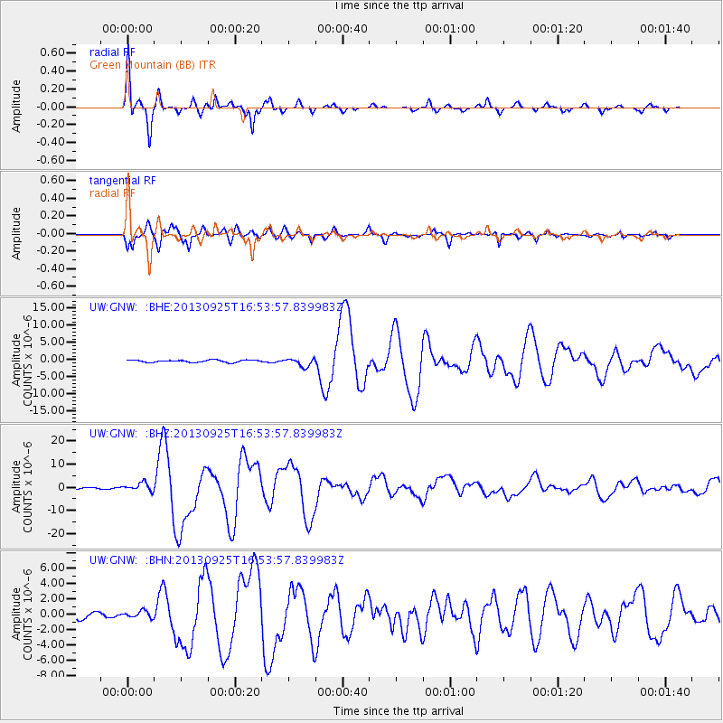
Earthquake location: Near Coast Of Peru
Earthquake latitude/longitude: -15.8/-74.5
Earthquake time(UTC): 2013/09/25 (268) 16:42:43 GMT
Earthquake Depth: 40 km
Earthquake Magnitude: 7.1 MWW, 6.8 MI, 7.0 MWB, 7.0 MWC, 7.1 MWW, 7.1 MWC
Earthquake Catalog/Contributor: NEIC PDE/NEIC COMCAT
Network: UW Pacific Northwest Regional Seismic Network
Station: GNW Green Mountain (BB)
Lat/Lon: 47.56 N/122.83 W
Elevation: 160 m
Distance: 76.5 deg
Az: 328.655 deg
Baz: 132.326 deg
Ray Param: 0.050907485
Estimated Moho Depth: 36.75 km
Estimated Crust Vp/Vs: 2.01
Assumed Crust Vp: 6.566 km/s
Estimated Crust Vs: 3.271 km/s
Estimated Crust Poisson's Ratio: 0.33
Radial Match: 97.480415 %
Radial Bump: 299
Transverse Match: 95.99733 %
Transverse Bump: 400
SOD ConfigId: 626651
Insert Time: 2014-04-18 20:55:56.099 +0000
GWidth: 2.5
Max Bumps: 400
Tol: 0.001

Signal To Noise

ChannelStoNSTALTA
UW:GNW: :BHZ:20130925T16:53:57.839983Z5.1537191.783416E-63.4604446E-7
UW:GNW: :BHN:20130925T16:53:57.839983Z1.38891434.5741575E-73.293333E-7
UW:GNW: :BHE:20130925T16:53:57.839983Z3.4615261.2039079E-63.4779688E-7
Arrivals
Ps5.8 SECOND
PpPs16 SECOND
PsPs/PpSs22 SECOND