You are here: Home > Network List > TA - USArray Transportable Network (new EarthScope stations) Stations List
> Station A04D Lummi Island, WA, USA > Earthquake Result Viewer
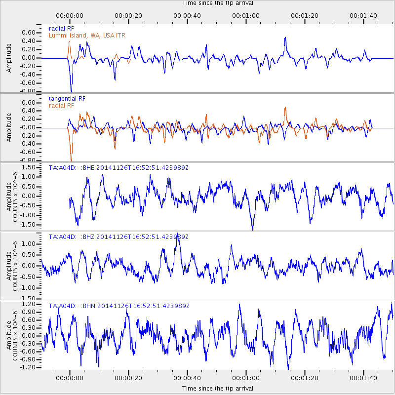
A04D Lummi Island, WA, USA - Earthquake Result Viewer
*The percent match for this event was below the threshold and hence no stack was calculated.
| Earthquake location: |
New Ireland Region, P.N.G. |
| Earthquake latitude/longitude: |
-4.7/153.0 |
| Earthquake time(UTC): |
2014/11/26 (330) 16:40:30 GMT |
| Earthquake Depth: |
55 km |
| Earthquake Magnitude: |
5.0 mb, 5.0 mb |
| Earthquake Catalog/Contributor: |
ISC/ISC |
|
| Network: |
TA USArray Transportable Network (new EarthScope stations) |
| Station: |
A04D Lummi Island, WA, USA |
| Lat/Lon: |
48.72 N/122.71 W |
| Elevation: |
13 m |
|
| Distance: |
89.8 deg |
| Az: |
41.221 deg |
| Baz: |
262.608 deg |
| Ray Param: |
$rayparam |
*The percent match for this event was below the threshold and hence was not used in the summary stack. |
|
| Radial Match: |
66.81356 % |
| Radial Bump: |
400 |
| Transverse Match: |
66.11929 % |
| Transverse Bump: |
400 |
| SOD ConfigId: |
3390531 |
| Insert Time: |
2019-04-15 05:15:04.556 +0000 |
| GWidth: |
2.5 |
| Max Bumps: |
400 |
| Tol: |
0.001 |
|
Signal To Noise
| Channel | StoN | STA | LTA |
| TA:A04D: :BHZ:20141126T16:52:51.423989Z | 1.3773329 | 4.6566788E-7 | 3.380939E-7 |
| TA:A04D: :BHN:20141126T16:52:51.423989Z | 1.0212247 | 5.2049745E-7 | 5.0967964E-7 |
| TA:A04D: :BHE:20141126T16:52:51.423989Z | 0.9428694 | 5.21913E-7 | 5.5353695E-7 |
| Arrivals |
| Ps | |
| PpPs | |
| PsPs/PpSs | |


