You are here: Home > Network List > G - GEOSCOPE Stations List
> Station CLF Chambon la Foret observatory, France > Earthquake Result Viewer
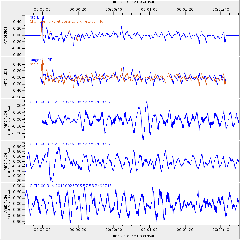
CLF Chambon la Foret observatory, France - Earthquake Result Viewer
*The percent match for this event was below the threshold and hence no stack was calculated.
| Earthquake location: |
Near Coast Of Chiapas, Mexico |
| Earthquake latitude/longitude: |
14.4/-93.4 |
| Earthquake time(UTC): |
2013/09/26 (269) 06:46:03 GMT |
| Earthquake Depth: |
8.8 km |
| Earthquake Magnitude: |
5.5 MWB, 5.7 MWC |
| Earthquake Catalog/Contributor: |
NEIC PDE/NEIC COMCAT |
|
| Network: |
G GEOSCOPE |
| Station: |
CLF Chambon la Foret observatory, France |
| Lat/Lon: |
48.03 N/2.26 E |
| Elevation: |
145 m |
|
| Distance: |
83.1 deg |
| Az: |
42.288 deg |
| Baz: |
283.807 deg |
| Ray Param: |
$rayparam |
*The percent match for this event was below the threshold and hence was not used in the summary stack. |
|
| Radial Match: |
55.979534 % |
| Radial Bump: |
400 |
| Transverse Match: |
53.678993 % |
| Transverse Bump: |
374 |
| SOD ConfigId: |
626651 |
| Insert Time: |
2014-04-18 21:06:08.000 +0000 |
| GWidth: |
2.5 |
| Max Bumps: |
400 |
| Tol: |
0.001 |
|
Signal To Noise
| Channel | StoN | STA | LTA |
| G:CLF:00:BHZ:20130926T06:57:58.249971Z | 1.7859294 | 4.937562E-7 | 2.764702E-7 |
| G:CLF:00:BHN:20130926T06:57:58.249971Z | 0.85606706 | 2.7922894E-7 | 3.261765E-7 |
| G:CLF:00:BHE:20130926T06:57:58.249971Z | 1.0241725 | 2.7910767E-7 | 2.7252017E-7 |
| Arrivals |
| Ps | |
| PpPs | |
| PsPs/PpSs | |


