You are here: Home > Network List > CI - Caltech Regional Seismic Network Stations List
> Station TIN Tinemaha, Big Pine, CA, USA > Earthquake Result Viewer
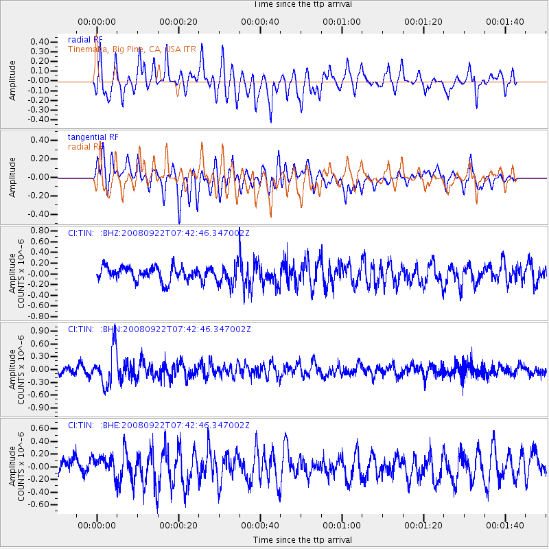
TIN Tinemaha, Big Pine, CA, USA - Earthquake Result Viewer
*The percent match for this event was below the threshold and hence no stack was calculated.
| Earthquake location: |
Hokkaido, Japan Region |
| Earthquake latitude/longitude: |
41.6/140.4 |
| Earthquake time(UTC): |
2008/09/22 (266) 07:31:59 GMT |
| Earthquake Depth: |
149 km |
| Earthquake Magnitude: |
5.7 MW, 5.3 MB, 5.6 MW |
| Earthquake Catalog/Contributor: |
WHDF/NEIC |
|
| Network: |
CI Caltech Regional Seismic Network |
| Station: |
TIN Tinemaha, Big Pine, CA, USA |
| Lat/Lon: |
37.05 N/118.23 W |
| Elevation: |
1197 m |
|
| Distance: |
73.8 deg |
| Az: |
54.77 deg |
| Baz: |
309.999 deg |
| Ray Param: |
$rayparam |
*The percent match for this event was below the threshold and hence was not used in the summary stack. |
|
| Radial Match: |
73.291954 % |
| Radial Bump: |
400 |
| Transverse Match: |
62.282494 % |
| Transverse Bump: |
400 |
| SOD ConfigId: |
2560 |
| Insert Time: |
2010-02-25 20:52:25.923 +0000 |
| GWidth: |
2.5 |
| Max Bumps: |
400 |
| Tol: |
0.001 |
|
Signal To Noise
| Channel | StoN | STA | LTA |
| CI:TIN: :BHN:20080922T07:42:46.347002Z | 5.535627 | 4.4498432E-7 | 8.038553E-8 |
| CI:TIN: :BHE:20080922T07:42:46.347002Z | 0.9067045 | 1.3890866E-7 | 1.5320168E-7 |
| CI:TIN: :BHZ:20080922T07:42:46.347002Z | 1.6052622 | 2.0128793E-7 | 1.2539256E-7 |
| Arrivals |
| Ps | |
| PpPs | |
| PsPs/PpSs | |


