You are here: Home > Network List > TA - USArray Transportable Network (new EarthScope stations) Stations List
> Station J54A Appleton, NY, USA > Earthquake Result Viewer
J54A Appleton, NY, USA - Earthquake Result Viewer
| Earthquake location: |
Near Coast Of Chiapas, Mexico |
| Earthquake latitude/longitude: |
14.4/-93.4 |
| Earthquake time(UTC): |
2013/09/26 (269) 06:46:03 GMT |
| Earthquake Depth: |
8.8 km |
| Earthquake Magnitude: |
5.5 MWB, 5.7 MWC |
| Earthquake Catalog/Contributor: |
NEIC PDE/NEIC COMCAT |
|
| Network: |
TA USArray Transportable Network (new EarthScope stations) |
| Station: |
J54A Appleton, NY, USA |
| Lat/Lon: |
43.27 N/78.64 W |
| Elevation: |
112 m |
|
| Distance: |
31.4 deg |
| Az: |
20.904 deg |
| Baz: |
208.248 deg |
| Ray Param: |
0.07908007 |
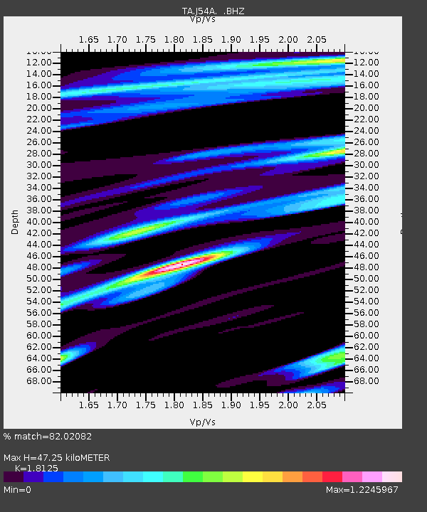
| Estimated Moho Depth: |
47.25 km |
| Estimated Crust Vp/Vs: |
1.81 |
| Assumed Crust Vp: |
6.419 km/s |
| Estimated Crust Vs: |
3.542 km/s |
| Estimated Crust Poisson's Ratio: |
0.28 |
|
| Radial Match: |
82.02082 % |
| Radial Bump: |
400 |
| Transverse Match: |
51.769005 % |
| Transverse Bump: |
400 |
| SOD ConfigId: |
626651 |
| Insert Time: |
2014-04-18 21:16:48.612 +0000 |
| GWidth: |
2.5 |
| Max Bumps: |
400 |
| Tol: |
0.001 |
|
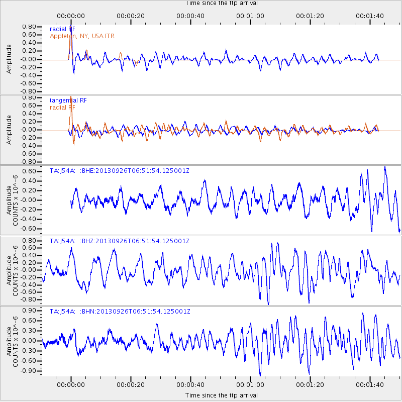
Signal To Noise
| Channel | StoN | STA | LTA |
| TA:J54A: :BHZ:20130926T06:51:54.125001Z | 2.423027 | 3.7374835E-7 | 1.5424853E-7 |
| TA:J54A: :BHN:20130926T06:51:54.125001Z | 2.1352878 | 2.4498564E-7 | 1.14731904E-7 |
| TA:J54A: :BHE:20130926T06:51:54.125001Z | 1.7101268 | 1.8647893E-7 | 1.0904392E-7 |
| Arrivals |
| Ps | 6.5 SECOND |
| PpPs | 19 SECOND |
| PsPs/PpSs | 26 SECOND |


