You are here: Home > Network List > TA - USArray Transportable Network (new EarthScope stations) Stations List
> Station J58A Remsen, NY, USA > Earthquake Result Viewer
J58A Remsen, NY, USA - Earthquake Result Viewer
| Earthquake location: |
Near Coast Of Chiapas, Mexico |
| Earthquake latitude/longitude: |
14.4/-93.4 |
| Earthquake time(UTC): |
2013/09/26 (269) 06:46:03 GMT |
| Earthquake Depth: |
8.8 km |
| Earthquake Magnitude: |
5.5 MWB, 5.7 MWC |
| Earthquake Catalog/Contributor: |
NEIC PDE/NEIC COMCAT |
|
| Network: |
TA USArray Transportable Network (new EarthScope stations) |
| Station: |
J58A Remsen, NY, USA |
| Lat/Lon: |
43.36 N/75.29 W |
| Elevation: |
436 m |
|
| Distance: |
32.7 deg |
| Az: |
24.77 deg |
| Baz: |
213.817 deg |
| Ray Param: |
0.07852552 |
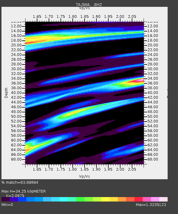
| Estimated Moho Depth: |
34.25 km |
| Estimated Crust Vp/Vs: |
2.10 |
| Assumed Crust Vp: |
6.419 km/s |
| Estimated Crust Vs: |
3.06 km/s |
| Estimated Crust Poisson's Ratio: |
0.35 |
|
| Radial Match: |
83.86964 % |
| Radial Bump: |
294 |
| Transverse Match: |
52.535828 % |
| Transverse Bump: |
390 |
| SOD ConfigId: |
626651 |
| Insert Time: |
2014-04-18 21:16:55.457 +0000 |
| GWidth: |
2.5 |
| Max Bumps: |
400 |
| Tol: |
0.001 |
|

Signal To Noise
| Channel | StoN | STA | LTA |
| TA:J58A: :BHZ:20130926T06:52:05.825013Z | 2.9292889 | 3.8393017E-7 | 1.3106599E-7 |
| TA:J58A: :BHN:20130926T06:52:05.825013Z | 2.092816 | 3.2262778E-7 | 1.5415965E-7 |
| TA:J58A: :BHE:20130926T06:52:05.825013Z | 1.5253725 | 2.0398106E-7 | 1.3372541E-7 |
| Arrivals |
| Ps | 6.3 SECOND |
| PpPs | 15 SECOND |
| PsPs/PpSs | 22 SECOND |


