You are here: Home > Network List > TA - USArray Transportable Network (new EarthScope stations) Stations List
> Station G59A Clarenceville, QC, USA > Earthquake Result Viewer
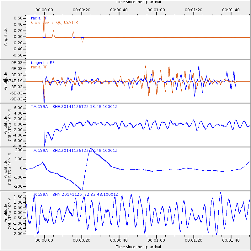
G59A Clarenceville, QC, USA - Earthquake Result Viewer
*The percent match for this event was below the threshold and hence no stack was calculated.
| Earthquake location: |
Northern East Pacific Rise |
| Earthquake latitude/longitude: |
8.3/-104.1 |
| Earthquake time(UTC): |
2014/11/26 (330) 22:26:00 GMT |
| Earthquake Depth: |
10 km |
| Earthquake Magnitude: |
5.5 MW, 5.1 MS, 5.0 mb |
| Earthquake Catalog/Contributor: |
ISC/ISC |
|
| Network: |
TA USArray Transportable Network (new EarthScope stations) |
| Station: |
G59A Clarenceville, QC, USA |
| Lat/Lon: |
45.08 N/73.18 W |
| Elevation: |
36 m |
|
| Distance: |
45.3 deg |
| Az: |
30.788 deg |
| Baz: |
225.641 deg |
| Ray Param: |
$rayparam |
*The percent match for this event was below the threshold and hence was not used in the summary stack. |
|
| Radial Match: |
69.57037 % |
| Radial Bump: |
400 |
| Transverse Match: |
68.04155 % |
| Transverse Bump: |
400 |
| SOD ConfigId: |
3390531 |
| Insert Time: |
2019-04-15 05:21:23.616 +0000 |
| GWidth: |
2.5 |
| Max Bumps: |
400 |
| Tol: |
0.001 |
|
Signal To Noise
| Channel | StoN | STA | LTA |
| TA:G59A: :BHZ:20141126T22:33:48.10001Z | 0.74200934 | 1.132085E-4 | 1.5257018E-4 |
| TA:G59A: :BHN:20141126T22:33:48.10001Z | 0.6229757 | 6.923889E-7 | 1.111422E-6 |
| TA:G59A: :BHE:20141126T22:33:48.10001Z | 0.82030845 | 1.7105044E-6 | 2.0851967E-6 |
| Arrivals |
| Ps | |
| PpPs | |
| PsPs/PpSs | |


