You are here: Home > Network List > TA - USArray Transportable Network (new EarthScope stations) Stations List
> Station M51A Elyria, OH, USA > Earthquake Result Viewer
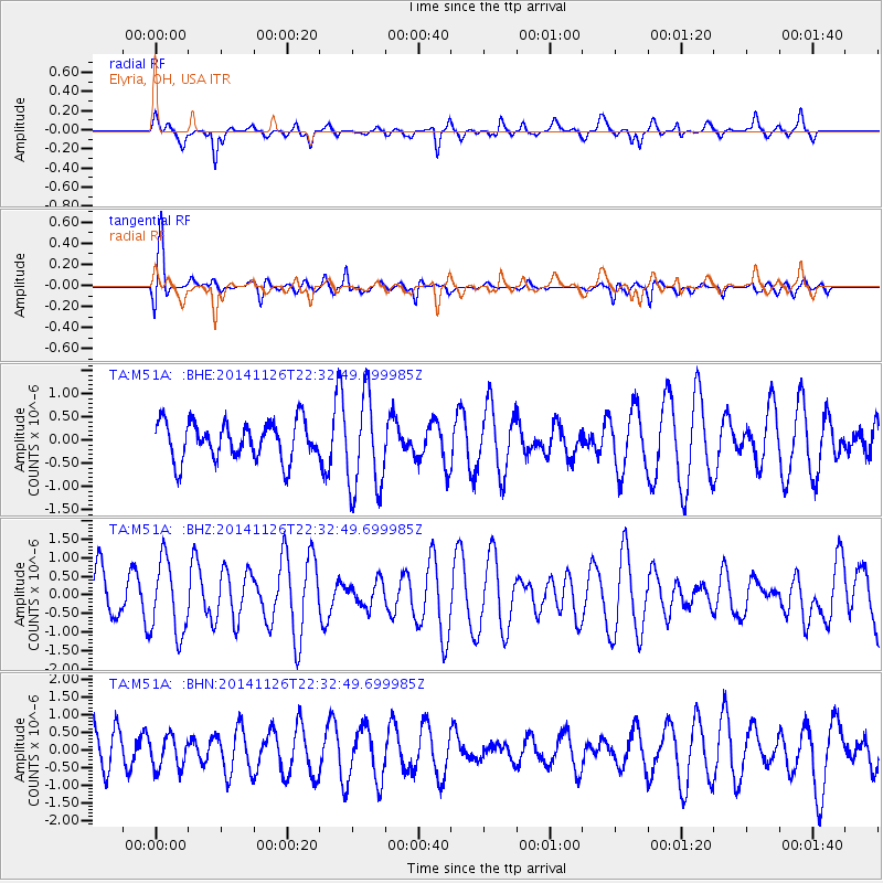
M51A Elyria, OH, USA - Earthquake Result Viewer
*The percent match for this event was below the threshold and hence no stack was calculated.
| Earthquake location: |
Northern East Pacific Rise |
| Earthquake latitude/longitude: |
8.3/-104.1 |
| Earthquake time(UTC): |
2014/11/26 (330) 22:26:00 GMT |
| Earthquake Depth: |
10 km |
| Earthquake Magnitude: |
5.5 MW, 5.1 MS, 5.0 mb |
| Earthquake Catalog/Contributor: |
ISC/ISC |
|
| Network: |
TA USArray Transportable Network (new EarthScope stations) |
| Station: |
M51A Elyria, OH, USA |
| Lat/Lon: |
41.33 N/82.18 W |
| Elevation: |
239 m |
|
| Distance: |
38.2 deg |
| Az: |
27.047 deg |
| Baz: |
216.693 deg |
| Ray Param: |
$rayparam |
*The percent match for this event was below the threshold and hence was not used in the summary stack. |
|
| Radial Match: |
61.680294 % |
| Radial Bump: |
400 |
| Transverse Match: |
79.43526 % |
| Transverse Bump: |
400 |
| SOD ConfigId: |
3390531 |
| Insert Time: |
2019-04-15 05:21:38.769 +0000 |
| GWidth: |
2.5 |
| Max Bumps: |
400 |
| Tol: |
0.001 |
|
Signal To Noise
| Channel | StoN | STA | LTA |
| TA:M51A: :BHZ:20141126T22:32:49.699985Z | 1.4271274 | 9.990162E-7 | 7.0001886E-7 |
| TA:M51A: :BHN:20141126T22:32:49.699985Z | 0.68096495 | 4.4337156E-7 | 6.510931E-7 |
| TA:M51A: :BHE:20141126T22:32:49.699985Z | 2.5395744 | 1.0388758E-6 | 4.0907474E-7 |
| Arrivals |
| Ps | |
| PpPs | |
| PsPs/PpSs | |


