You are here: Home > Network List > TA - USArray Transportable Network (new EarthScope stations) Stations List
> Station L59A Walton, NY, USA > Earthquake Result Viewer
L59A Walton, NY, USA - Earthquake Result Viewer
| Earthquake location: |
Near Coast Of Chiapas, Mexico |
| Earthquake latitude/longitude: |
14.4/-93.4 |
| Earthquake time(UTC): |
2013/09/26 (269) 06:46:03 GMT |
| Earthquake Depth: |
8.8 km |
| Earthquake Magnitude: |
5.5 MWB, 5.7 MWC |
| Earthquake Catalog/Contributor: |
NEIC PDE/NEIC COMCAT |
|
| Network: |
TA USArray Transportable Network (new EarthScope stations) |
| Station: |
L59A Walton, NY, USA |
| Lat/Lon: |
42.19 N/75.04 W |
| Elevation: |
677 m |
|
| Distance: |
31.9 deg |
| Az: |
26.286 deg |
| Baz: |
215.263 deg |
| Ray Param: |
0.07889215 |
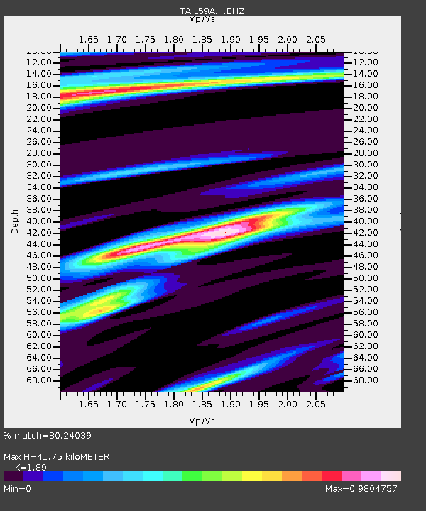
| Estimated Moho Depth: |
41.75 km |
| Estimated Crust Vp/Vs: |
1.89 |
| Assumed Crust Vp: |
6.419 km/s |
| Estimated Crust Vs: |
3.396 km/s |
| Estimated Crust Poisson's Ratio: |
0.31 |
|
| Radial Match: |
80.24039 % |
| Radial Bump: |
258 |
| Transverse Match: |
54.14933 % |
| Transverse Bump: |
324 |
| SOD ConfigId: |
626651 |
| Insert Time: |
2014-04-18 21:17:44.154 +0000 |
| GWidth: |
2.5 |
| Max Bumps: |
400 |
| Tol: |
0.001 |
|

Signal To Noise
| Channel | StoN | STA | LTA |
| TA:L59A: :BHZ:20130926T06:51:58.273988Z | 2.677307 | 4.7113076E-7 | 1.7597189E-7 |
| TA:L59A: :BHN:20130926T06:51:58.273988Z | 0.70328254 | 1.5334183E-7 | 2.1803733E-7 |
| TA:L59A: :BHE:20130926T06:51:58.273988Z | 0.8715201 | 2.0307134E-7 | 2.3300821E-7 |
| Arrivals |
| Ps | 6.2 SECOND |
| PpPs | 17 SECOND |
| PsPs/PpSs | 24 SECOND |


