You are here: Home > Network List > TA - USArray Transportable Network (new EarthScope stations) Stations List
> Station M04C Macdoel, CA, USA > Earthquake Result Viewer
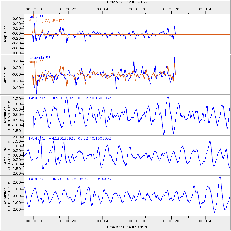
M04C Macdoel, CA, USA - Earthquake Result Viewer
*The percent match for this event was below the threshold and hence no stack was calculated.
| Earthquake location: |
Near Coast Of Chiapas, Mexico |
| Earthquake latitude/longitude: |
14.4/-93.4 |
| Earthquake time(UTC): |
2013/09/26 (269) 06:46:03 GMT |
| Earthquake Depth: |
8.8 km |
| Earthquake Magnitude: |
5.5 MWB, 5.7 MWC |
| Earthquake Catalog/Contributor: |
NEIC PDE/NEIC COMCAT |
|
| Network: |
TA USArray Transportable Network (new EarthScope stations) |
| Station: |
M04C Macdoel, CA, USA |
| Lat/Lon: |
41.78 N/121.84 W |
| Elevation: |
1391 m |
|
| Distance: |
36.7 deg |
| Az: |
323.424 deg |
| Baz: |
129.474 deg |
| Ray Param: |
$rayparam |
*The percent match for this event was below the threshold and hence was not used in the summary stack. |
|
| Radial Match: |
28.066664 % |
| Radial Bump: |
400 |
| Transverse Match: |
66.74741 % |
| Transverse Bump: |
313 |
| SOD ConfigId: |
626651 |
| Insert Time: |
2014-04-18 21:17:55.891 +0000 |
| GWidth: |
2.5 |
| Max Bumps: |
400 |
| Tol: |
0.001 |
|
Signal To Noise
| Channel | StoN | STA | LTA |
| TA:M04C: :HHZ:20130926T06:52:40.160005Z | 2.0517604 | 9.1654044E-7 | 4.4670932E-7 |
| TA:M04C: :HHN:20130926T06:52:40.160005Z | 0.69330513 | 7.1664186E-7 | 1.03366E-6 |
| TA:M04C: :HHE:20130926T06:52:40.160005Z | 0.8766196 | 6.3433004E-7 | 7.236093E-7 |
| Arrivals |
| Ps | |
| PpPs | |
| PsPs/PpSs | |


