You are here: Home > Network List > US - United States National Seismic Network Stations List
> Station BMO Blue Mountains Array (Baker), Oregon, USA > Earthquake Result Viewer
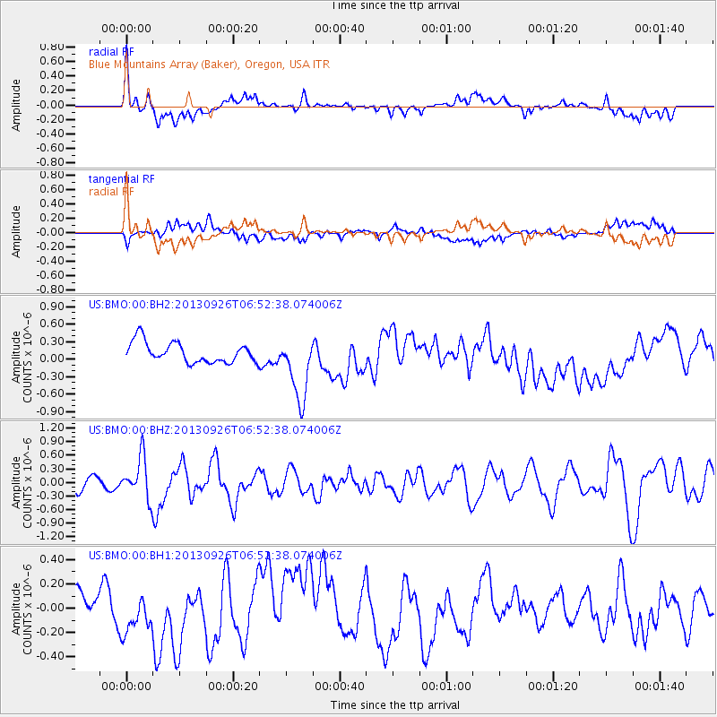
BMO Blue Mountains Array (Baker), Oregon, USA - Earthquake Result Viewer
*The percent match for this event was below the threshold and hence no stack was calculated.
| Earthquake location: |
Near Coast Of Chiapas, Mexico |
| Earthquake latitude/longitude: |
14.4/-93.4 |
| Earthquake time(UTC): |
2013/09/26 (269) 06:46:03 GMT |
| Earthquake Depth: |
8.8 km |
| Earthquake Magnitude: |
5.5 MWB, 5.7 MWC |
| Earthquake Catalog/Contributor: |
NEIC PDE/NEIC COMCAT |
|
| Network: |
US United States National Seismic Network |
| Station: |
BMO Blue Mountains Array (Baker), Oregon, USA |
| Lat/Lon: |
44.85 N/117.31 W |
| Elevation: |
1189 m |
|
| Distance: |
36.5 deg |
| Az: |
330.979 deg |
| Baz: |
138.643 deg |
| Ray Param: |
$rayparam |
*The percent match for this event was below the threshold and hence was not used in the summary stack. |
|
| Radial Match: |
40.68417 % |
| Radial Bump: |
400 |
| Transverse Match: |
39.048462 % |
| Transverse Bump: |
400 |
| SOD ConfigId: |
626651 |
| Insert Time: |
2014-04-18 21:19:03.990 +0000 |
| GWidth: |
2.5 |
| Max Bumps: |
400 |
| Tol: |
0.001 |
|
Signal To Noise
| Channel | StoN | STA | LTA |
| US:BMO:00:BHZ:20130926T06:52:38.074006Z | 2.5780516 | 4.6415988E-7 | 1.8004289E-7 |
| US:BMO:00:BH1:20130926T06:52:38.074006Z | 1.2883371 | 1.7778866E-7 | 1.3799855E-7 |
| US:BMO:00:BH2:20130926T06:52:38.074006Z | 3.274762 | 5.6698525E-7 | 1.7313785E-7 |
| Arrivals |
| Ps | |
| PpPs | |
| PsPs/PpSs | |


