You are here: Home > Network List > US - United States National Seismic Network Stations List
> Station EGMT Eagleton, Montana, USA > Earthquake Result Viewer
EGMT Eagleton, Montana, USA - Earthquake Result Viewer
*The percent match for this event was below the threshold and hence no stack was calculated.
| Earthquake location: |
Near Coast Of Chiapas, Mexico |
| Earthquake latitude/longitude: |
14.4/-93.4 |
| Earthquake time(UTC): |
2013/09/26 (269) 06:46:03 GMT |
| Earthquake Depth: |
8.8 km |
| Earthquake Magnitude: |
5.5 MWB, 5.7 MWC |
| Earthquake Catalog/Contributor: |
NEIC PDE/NEIC COMCAT |
|
| Network: |
US United States National Seismic Network |
| Station: |
EGMT Eagleton, Montana, USA |
| Lat/Lon: |
48.02 N/109.75 W |
| Elevation: |
1055 m |
|
| Distance: |
36.1 deg |
| Az: |
341.287 deg |
| Baz: |
152.418 deg |
| Ray Param: |
$rayparam |
*The percent match for this event was below the threshold and hence was not used in the summary stack. |
|
| Radial Match: |
67.892685 % |
| Radial Bump: |
400 |
| Transverse Match: |
72.73121 % |
| Transverse Bump: |
400 |
| SOD ConfigId: |
626651 |
| Insert Time: |
2014-04-18 21:19:18.453 +0000 |
| GWidth: |
2.5 |
| Max Bumps: |
400 |
| Tol: |
0.001 |
|
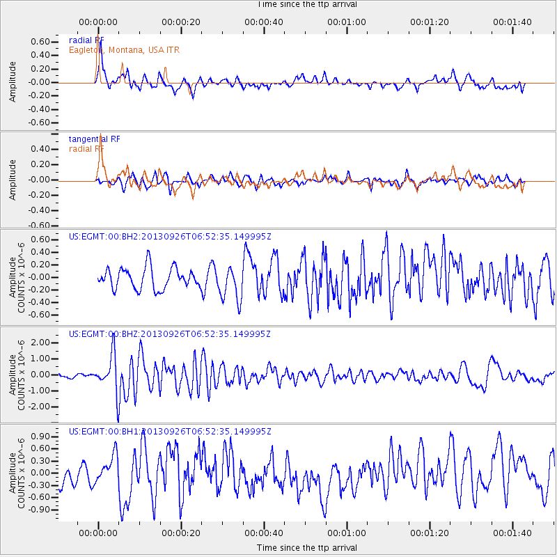
Signal To Noise
| Channel | StoN | STA | LTA |
| US:EGMT:00:BHZ:20130926T06:52:35.149995Z | 11.034583 | 1.1963789E-6 | 1.0842085E-7 |
| US:EGMT:00:BH1:20130926T06:52:35.149995Z | 1.1512496 | 3.473503E-7 | 3.0171586E-7 |
| US:EGMT:00:BH2:20130926T06:52:35.149995Z | 1.6744417 | 2.7750727E-7 | 1.6573121E-7 |
| Arrivals |
| Ps | |
| PpPs | |
| PsPs/PpSs | |


