You are here: Home > Network List > US - United States National Seismic Network Stations List
> Station LONY Lake Ozonia, New York, USA > Earthquake Result Viewer
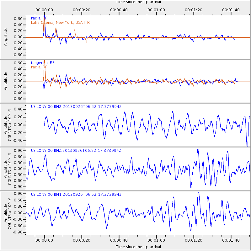
LONY Lake Ozonia, New York, USA - Earthquake Result Viewer
*The percent match for this event was below the threshold and hence no stack was calculated.
| Earthquake location: |
Near Coast Of Chiapas, Mexico |
| Earthquake latitude/longitude: |
14.4/-93.4 |
| Earthquake time(UTC): |
2013/09/26 (269) 06:46:03 GMT |
| Earthquake Depth: |
8.8 km |
| Earthquake Magnitude: |
5.5 MWB, 5.7 MWC |
| Earthquake Catalog/Contributor: |
NEIC PDE/NEIC COMCAT |
|
| Network: |
US United States National Seismic Network |
| Station: |
LONY Lake Ozonia, New York, USA |
| Lat/Lon: |
44.62 N/74.58 W |
| Elevation: |
440 m |
|
| Distance: |
34.1 deg |
| Az: |
24.261 deg |
| Baz: |
213.879 deg |
| Ray Param: |
$rayparam |
*The percent match for this event was below the threshold and hence was not used in the summary stack. |
|
| Radial Match: |
73.743195 % |
| Radial Bump: |
319 |
| Transverse Match: |
57.3393 % |
| Transverse Bump: |
400 |
| SOD ConfigId: |
626651 |
| Insert Time: |
2014-04-18 21:19:32.908 +0000 |
| GWidth: |
2.5 |
| Max Bumps: |
400 |
| Tol: |
0.001 |
|
Signal To Noise
| Channel | StoN | STA | LTA |
| US:LONY:00:BHZ:20130926T06:52:17.373994Z | 1.8523371 | 4.097328E-7 | 2.2119775E-7 |
| US:LONY:00:BH1:20130926T06:52:17.373994Z | 2.9341016 | 2.7256525E-7 | 9.289564E-8 |
| US:LONY:00:BH2:20130926T06:52:17.373994Z | 1.9568561 | 2.0950085E-7 | 1.0705992E-7 |
| Arrivals |
| Ps | |
| PpPs | |
| PsPs/PpSs | |


