You are here: Home > Network List > US - United States National Seismic Network Stations List
> Station MSO Missoula, Montana, USA > Earthquake Result Viewer
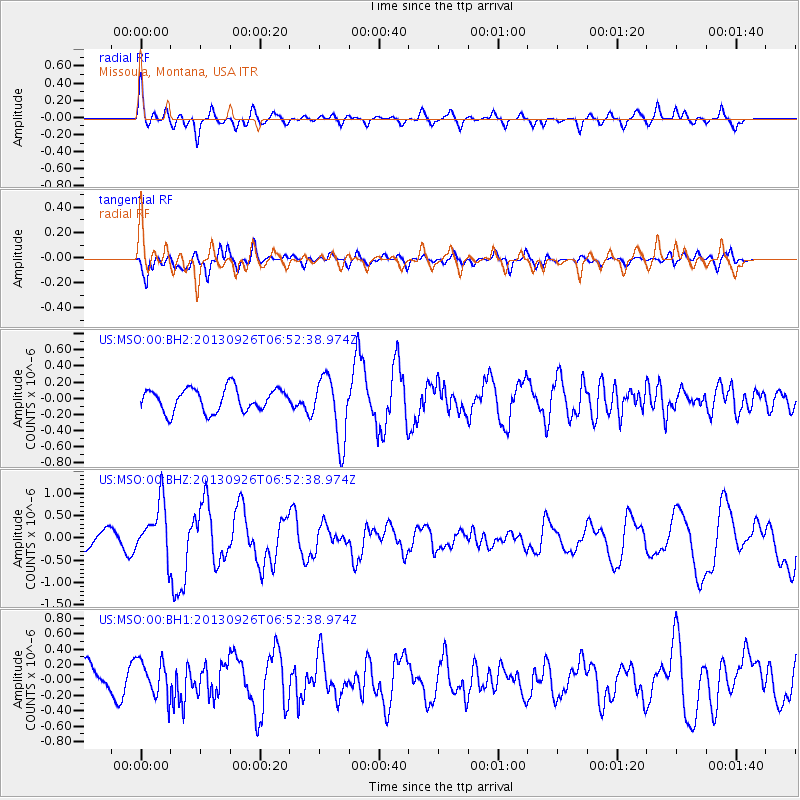
MSO Missoula, Montana, USA - Earthquake Result Viewer
*The percent match for this event was below the threshold and hence no stack was calculated.
| Earthquake location: |
Near Coast Of Chiapas, Mexico |
| Earthquake latitude/longitude: |
14.4/-93.4 |
| Earthquake time(UTC): |
2013/09/26 (269) 06:46:03 GMT |
| Earthquake Depth: |
8.8 km |
| Earthquake Magnitude: |
5.5 MWB, 5.7 MWC |
| Earthquake Catalog/Contributor: |
NEIC PDE/NEIC COMCAT |
|
| Network: |
US United States National Seismic Network |
| Station: |
MSO Missoula, Montana, USA |
| Lat/Lon: |
46.83 N/113.94 W |
| Elevation: |
1264 m |
|
| Distance: |
36.6 deg |
| Az: |
336.142 deg |
| Baz: |
145.2 deg |
| Ray Param: |
$rayparam |
*The percent match for this event was below the threshold and hence was not used in the summary stack. |
|
| Radial Match: |
74.79738 % |
| Radial Bump: |
400 |
| Transverse Match: |
57.99415 % |
| Transverse Bump: |
400 |
| SOD ConfigId: |
626651 |
| Insert Time: |
2014-04-18 21:19:34.642 +0000 |
| GWidth: |
2.5 |
| Max Bumps: |
400 |
| Tol: |
0.001 |
|
Signal To Noise
| Channel | StoN | STA | LTA |
| US:MSO:00:BHZ:20130926T06:52:38.974Z | 3.1356044 | 6.1371475E-7 | 1.9572454E-7 |
| US:MSO:00:BH1:20130926T06:52:38.974Z | 1.3292191 | 2.4304373E-7 | 1.82847E-7 |
| US:MSO:00:BH2:20130926T06:52:38.974Z | 2.8308659 | 4.0107977E-7 | 1.4168096E-7 |
| Arrivals |
| Ps | |
| PpPs | |
| PsPs/PpSs | |


