You are here: Home > Network List > UW - Pacific Northwest Regional Seismic Network Stations List
> Station LEBA Lebam, WA, USA > Earthquake Result Viewer
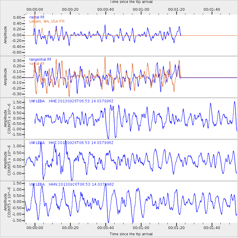
LEBA Lebam, WA, USA - Earthquake Result Viewer
*The percent match for this event was below the threshold and hence no stack was calculated.
| Earthquake location: |
Near Coast Of Chiapas, Mexico |
| Earthquake latitude/longitude: |
14.4/-93.4 |
| Earthquake time(UTC): |
2013/09/26 (269) 06:46:03 GMT |
| Earthquake Depth: |
8.8 km |
| Earthquake Magnitude: |
5.5 MWB, 5.7 MWC |
| Earthquake Catalog/Contributor: |
NEIC PDE/NEIC COMCAT |
|
| Network: |
UW Pacific Northwest Regional Seismic Network |
| Station: |
LEBA Lebam, WA, USA |
| Lat/Lon: |
46.55 N/123.56 W |
| Elevation: |
73 m |
|
| Distance: |
40.8 deg |
| Az: |
327.907 deg |
| Baz: |
131.775 deg |
| Ray Param: |
$rayparam |
*The percent match for this event was below the threshold and hence was not used in the summary stack. |
|
| Radial Match: |
47.377842 % |
| Radial Bump: |
384 |
| Transverse Match: |
41.238026 % |
| Transverse Bump: |
387 |
| SOD ConfigId: |
626651 |
| Insert Time: |
2014-04-18 21:20:33.745 +0000 |
| GWidth: |
2.5 |
| Max Bumps: |
400 |
| Tol: |
0.001 |
|
Signal To Noise
| Channel | StoN | STA | LTA |
| UW:LEBA: :HHZ:20130926T06:53:14.037996Z | 1.4509605 | 5.8659595E-7 | 4.042811E-7 |
| UW:LEBA: :HHN:20130926T06:53:14.037996Z | 1.7557495 | 9.5240176E-7 | 5.4244737E-7 |
| UW:LEBA: :HHE:20130926T06:53:14.037996Z | 1.0823787 | 3.3102003E-7 | 3.0582643E-7 |
| Arrivals |
| Ps | |
| PpPs | |
| PsPs/PpSs | |


