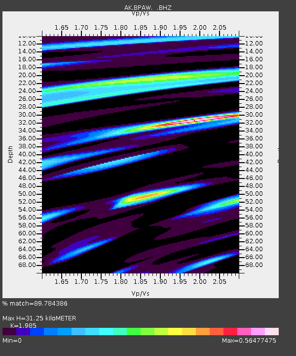
BPAW Bear Paw Mountain Broadband - Earthquake Result Viewer

Earthquake location: Pakistan
Earthquake latitude/longitude: 27.2/65.5
Earthquake time(UTC): 2013/09/28 (271) 07:34:06 GMT
Earthquake Depth: 12 km
Earthquake Magnitude: 6.8 MWW, 6.8 MWW, 6.8 MWC, 6.8 MWB, 6.9 MWC
Earthquake Catalog/Contributor: NEIC PDE/NEIC COMCAT
Network: AK Alaska Regional Network
Station: BPAW Bear Paw Mountain Broadband
Lat/Lon: 64.10 N/150.98 W
Elevation: 619 m
Distance: 84.6 deg
Az: 15.208 deg
Baz: 327.854 deg
Ray Param: 0.045346748
Estimated Moho Depth: 31.25 km
Estimated Crust Vp/Vs: 1.99
Assumed Crust Vp: 6.566 km/s
Estimated Crust Vs: 3.308 km/s
Estimated Crust Poisson's Ratio: 0.33
Radial Match: 89.784386 %
Radial Bump: 332
Transverse Match: 79.443245 %
Transverse Bump: 280
SOD ConfigId: 626651
Insert Time: 2014-04-18 21:22:53.203 +0000
GWidth: 2.5
Max Bumps: 400
Tol: 0.001

Signal To Noise

ChannelStoNSTALTA
AK:BPAW: :BHZ:20130928T07:46:08.207996Z7.73945242.8443967E-63.675191E-7
AK:BPAW: :BHN:20130928T07:46:08.207996Z1.23678647.496673E-76.061413E-7
AK:BPAW: :BHE:20130928T07:46:08.207996Z0.652108674.1397823E-76.3483014E-7
Arrivals
Ps4.8 SECOND
PpPs14 SECOND
PsPs/PpSs19 SECOND