You are here: Home > Network List > CB - China National Seismic Network Stations List
> Station HEH Heihe,Heilongjiang Province > Earthquake Result Viewer
HEH Heihe,Heilongjiang Province - Earthquake Result Viewer
| Earthquake location: |
Pakistan |
| Earthquake latitude/longitude: |
27.2/65.5 |
| Earthquake time(UTC): |
2013/09/28 (271) 07:34:06 GMT |
| Earthquake Depth: |
12 km |
| Earthquake Magnitude: |
6.8 MWW, 6.8 MWW, 6.8 MWC, 6.8 MWB, 6.9 MWC |
| Earthquake Catalog/Contributor: |
NEIC PDE/NEIC COMCAT |
|
| Network: |
CB China National Seismic Network |
| Station: |
HEH Heihe,Heilongjiang Province |
| Lat/Lon: |
50.25 N/127.41 E |
| Elevation: |
165 m |
|
| Distance: |
51.9 deg |
| Az: |
46.063 deg |
| Baz: |
267.816 deg |
| Ray Param: |
0.06713719 |
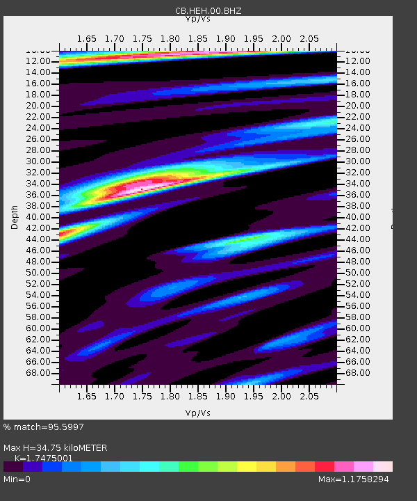
| Estimated Moho Depth: |
34.75 km |
| Estimated Crust Vp/Vs: |
1.75 |
| Assumed Crust Vp: |
6.419 km/s |
| Estimated Crust Vs: |
3.673 km/s |
| Estimated Crust Poisson's Ratio: |
0.26 |
|
| Radial Match: |
95.5997 % |
| Radial Bump: |
231 |
| Transverse Match: |
83.188156 % |
| Transverse Bump: |
400 |
| SOD ConfigId: |
626651 |
| Insert Time: |
2014-04-18 21:27:28.002 +0000 |
| GWidth: |
2.5 |
| Max Bumps: |
400 |
| Tol: |
0.001 |
|
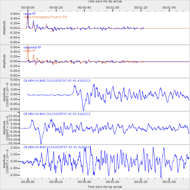
Signal To Noise
| Channel | StoN | STA | LTA |
| CB:HEH:00:BHZ:20130928T07:42:43.410022Z | 49.199837 | 5.1638344E-6 | 1.04956335E-7 |
| CB:HEH:00:BHN:20130928T07:42:43.410022Z | 1.3899432 | 2.3206212E-7 | 1.6695799E-7 |
| CB:HEH:00:BHE:20130928T07:42:43.410022Z | 23.597267 | 2.8779184E-6 | 1.2195981E-7 |
| Arrivals |
| Ps | 4.3 SECOND |
| PpPs | 14 SECOND |
| PsPs/PpSs | 18 SECOND |


