You are here: Home > Network List > CB - China National Seismic Network Stations List
> Station WHN Wuhantai,Hubei Province > Earthquake Result Viewer
WHN Wuhantai,Hubei Province - Earthquake Result Viewer
| Earthquake location: |
Pakistan |
| Earthquake latitude/longitude: |
27.2/65.5 |
| Earthquake time(UTC): |
2013/09/28 (271) 07:34:06 GMT |
| Earthquake Depth: |
12 km |
| Earthquake Magnitude: |
6.8 MWW, 6.8 MWW, 6.8 MWC, 6.8 MWB, 6.9 MWC |
| Earthquake Catalog/Contributor: |
NEIC PDE/NEIC COMCAT |
|
| Network: |
CB China National Seismic Network |
| Station: |
WHN Wuhantai,Hubei Province |
| Lat/Lon: |
30.54 N/114.35 E |
| Elevation: |
80 m |
|
| Distance: |
42.7 deg |
| Az: |
73.497 deg |
| Baz: |
278.113 deg |
| Ray Param: |
0.07304588 |
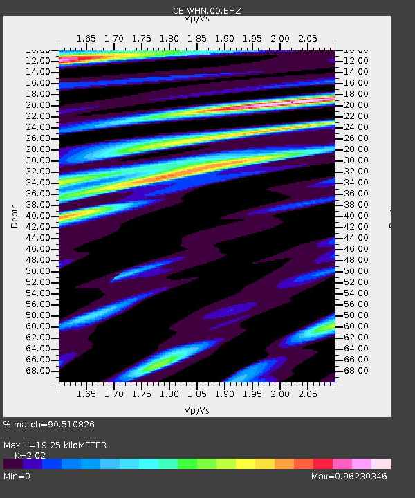
| Estimated Moho Depth: |
19.25 km |
| Estimated Crust Vp/Vs: |
2.02 |
| Assumed Crust Vp: |
6.276 km/s |
| Estimated Crust Vs: |
3.107 km/s |
| Estimated Crust Poisson's Ratio: |
0.34 |
|
| Radial Match: |
90.510826 % |
| Radial Bump: |
400 |
| Transverse Match: |
82.16346 % |
| Transverse Bump: |
400 |
| SOD ConfigId: |
626651 |
| Insert Time: |
2014-04-18 21:27:40.479 +0000 |
| GWidth: |
2.5 |
| Max Bumps: |
400 |
| Tol: |
0.001 |
|

Signal To Noise
| Channel | StoN | STA | LTA |
| CB:WHN:00:BHZ:20130928T07:41:31.840015Z | 34.465622 | 8.081974E-6 | 2.3449377E-7 |
| CB:WHN:00:BHN:20130928T07:41:31.840015Z | 5.9127827 | 1.4345093E-6 | 2.4261155E-7 |
| CB:WHN:00:BHE:20130928T07:41:31.840015Z | 22.419754 | 4.6718924E-6 | 2.0838287E-7 |
| Arrivals |
| Ps | 3.3 SECOND |
| PpPs | 8.8 SECOND |
| PsPs/PpSs | 12 SECOND |


