You are here: Home > Network List > CB - China National Seismic Network Stations List
> Station XLT Xilinhaote,Neimeng Province > Earthquake Result Viewer
XLT Xilinhaote,Neimeng Province - Earthquake Result Viewer
| Earthquake location: |
Pakistan |
| Earthquake latitude/longitude: |
27.2/65.5 |
| Earthquake time(UTC): |
2013/09/28 (271) 07:34:06 GMT |
| Earthquake Depth: |
12 km |
| Earthquake Magnitude: |
6.8 MWW, 6.8 MWW, 6.8 MWC, 6.8 MWB, 6.9 MWC |
| Earthquake Catalog/Contributor: |
NEIC PDE/NEIC COMCAT |
|
| Network: |
CB China National Seismic Network |
| Station: |
XLT Xilinhaote,Neimeng Province |
| Lat/Lon: |
43.90 N/116.08 E |
| Elevation: |
1030 m |
|
| Distance: |
43.7 deg |
| Az: |
53.918 deg |
| Baz: |
264.815 deg |
| Ray Param: |
0.0723751 |
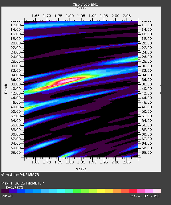
| Estimated Moho Depth: |
36.25 km |
| Estimated Crust Vp/Vs: |
1.79 |
| Assumed Crust Vp: |
6.459 km/s |
| Estimated Crust Vs: |
3.614 km/s |
| Estimated Crust Poisson's Ratio: |
0.27 |
|
| Radial Match: |
94.365875 % |
| Radial Bump: |
335 |
| Transverse Match: |
89.94683 % |
| Transverse Bump: |
400 |
| SOD ConfigId: |
626651 |
| Insert Time: |
2014-04-18 21:27:41.698 +0000 |
| GWidth: |
2.5 |
| Max Bumps: |
400 |
| Tol: |
0.001 |
|

Signal To Noise
| Channel | StoN | STA | LTA |
| CB:XLT:00:BHZ:20130928T07:41:40.330005Z | 55.64305 | 7.698917E-6 | 1.383626E-7 |
| CB:XLT:00:BHN:20130928T07:41:40.330005Z | 3.195202 | 3.1400583E-7 | 9.827417E-8 |
| CB:XLT:00:BHE:20130928T07:41:40.330005Z | 29.25105 | 4.2747743E-6 | 1.4614088E-7 |
| Arrivals |
| Ps | 4.7 SECOND |
| PpPs | 15 SECOND |
| PsPs/PpSs | 19 SECOND |


