You are here: Home > Network List > G - GEOSCOPE Stations List
> Station IVI Ivittuut, Greenland > Earthquake Result Viewer
IVI Ivittuut, Greenland - Earthquake Result Viewer
| Earthquake location: |
Pakistan |
| Earthquake latitude/longitude: |
27.2/65.5 |
| Earthquake time(UTC): |
2013/09/28 (271) 07:34:06 GMT |
| Earthquake Depth: |
12 km |
| Earthquake Magnitude: |
6.8 MWW, 6.8 MWW, 6.8 MWC, 6.8 MWB, 6.9 MWC |
| Earthquake Catalog/Contributor: |
NEIC PDE/NEIC COMCAT |
|
| Network: |
G GEOSCOPE |
| Station: |
IVI Ivittuut, Greenland |
| Lat/Lon: |
61.21 N/48.17 W |
| Elevation: |
15 m |
|
| Distance: |
77.0 deg |
| Az: |
332.935 deg |
| Baz: |
56.842 deg |
| Ray Param: |
0.050591815 |
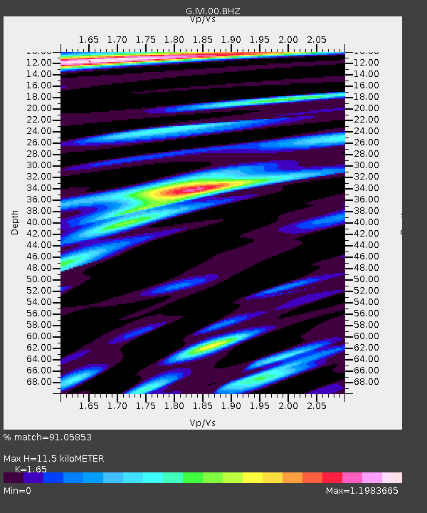
| Estimated Moho Depth: |
11.5 km |
| Estimated Crust Vp/Vs: |
1.65 |
| Assumed Crust Vp: |
6.472 km/s |
| Estimated Crust Vs: |
3.922 km/s |
| Estimated Crust Poisson's Ratio: |
0.21 |
|
| Radial Match: |
91.05853 % |
| Radial Bump: |
400 |
| Transverse Match: |
81.87552 % |
| Transverse Bump: |
400 |
| SOD ConfigId: |
626651 |
| Insert Time: |
2014-04-18 21:29:30.665 +0000 |
| GWidth: |
2.5 |
| Max Bumps: |
400 |
| Tol: |
0.001 |
|
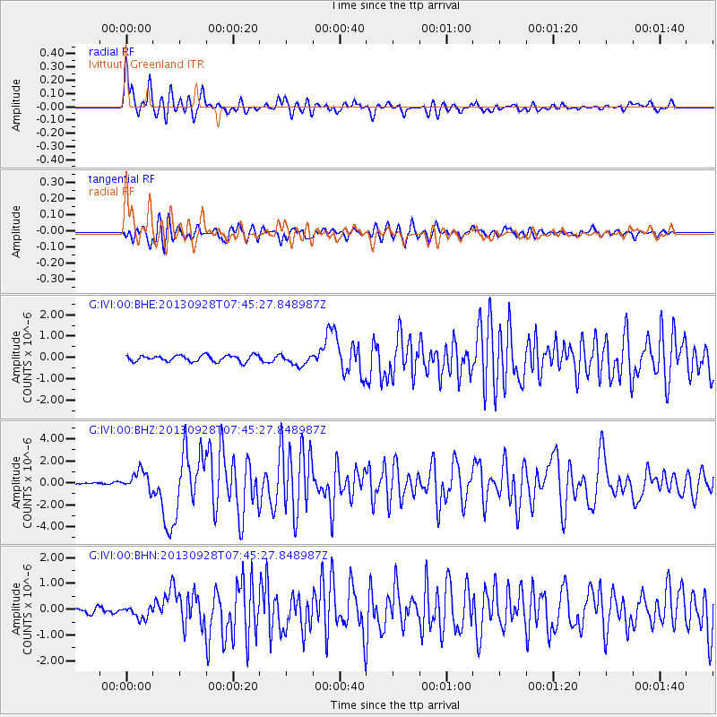
Signal To Noise
| Channel | StoN | STA | LTA |
| G:IVI:00:BHZ:20130928T07:45:27.848987Z | 7.20122 | 8.929344E-7 | 1.2399765E-7 |
| G:IVI:00:BHN:20130928T07:45:27.848987Z | 2.1808534 | 2.422784E-7 | 1.110934E-7 |
| G:IVI:00:BHE:20130928T07:45:27.848987Z | 1.8351703 | 2.6533422E-7 | 1.4458288E-7 |
| Arrivals |
| Ps | 1.2 SECOND |
| PpPs | 4.6 SECOND |
| PsPs/PpSs | 5.7 SECOND |


