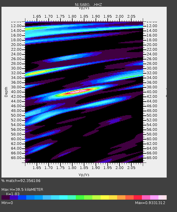
SABO Mt. Sabotino - Earthquake Result Viewer

Earthquake location: Pakistan
Earthquake latitude/longitude: 27.2/65.5
Earthquake time(UTC): 2013/09/28 (271) 07:34:06 GMT
Earthquake Depth: 12 km
Earthquake Magnitude: 6.8 MWW, 6.8 MWW, 6.8 MWC, 6.8 MWB, 6.9 MWC
Earthquake Catalog/Contributor: NEIC PDE/NEIC COMCAT
Network: NI North-East Italy Broadband Network
Station: SABO Mt. Sabotino
Lat/Lon: 45.99 N/13.63 E
Elevation: 621 m
Distance: 44.8 deg
Az: 308.926 deg
Baz: 96.307 deg
Ray Param: 0.07167077
Estimated Moho Depth: 39.5 km
Estimated Crust Vp/Vs: 1.83
Assumed Crust Vp: 6.207 km/s
Estimated Crust Vs: 3.392 km/s
Estimated Crust Poisson's Ratio: 0.29
Radial Match: 92.356186 %
Radial Bump: 400
Transverse Match: 81.861 %
Transverse Bump: 400
SOD ConfigId: 626651
Insert Time: 2014-04-18 21:34:40.925 +0000
GWidth: 2.5
Max Bumps: 400
Tol: 0.001

Signal To Noise

ChannelStoNSTALTA
NI:SABO: :HHZ:20130928T07:41:49.327991Z12.3704991.1750814E-69.499062E-8
NI:SABO: :HHN:20130928T07:41:49.327991Z1.99677062.4576013E-71.230788E-7
NI:SABO: :HHE:20130928T07:41:49.327991Z4.80405335.539207E-71.1530278E-7
Arrivals
Ps5.6 SECOND
PpPs17 SECOND
PsPs/PpSs23 SECOND