You are here: Home > Network List > TA - USArray Transportable Network (new EarthScope stations) Stations List
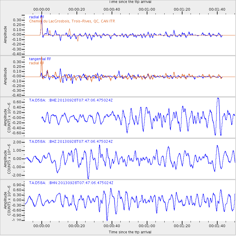
> Station D58A Chemin du LacGrosbois, Trois-Rives, QC, CAN > Earthquake Result Viewer
D58A Chemin du LacGrosbois, Trois-Rives, QC, CAN - Earthquake Result Viewer
| Earthquake location: |
Pakistan |
| Earthquake latitude/longitude: |
27.2/65.5 |
| Earthquake time(UTC): |
2013/09/28 (271) 07:34:06 GMT |
| Earthquake Depth: |
12 km |
| Earthquake Magnitude: |
6.8 MWW, 6.8 MWW, 6.8 MWC, 6.8 MWB, 6.9 MWC |
| Earthquake Catalog/Contributor: |
NEIC PDE/NEIC COMCAT |
|
| Network: |
TA USArray Transportable Network (new EarthScope stations) |
| Station: |
D58A Chemin du LacGrosbois, Trois-Rives, QC, CAN |
| Lat/Lon: |
47.10 N/72.88 W |
| Elevation: |
398 m |
|
| Distance: |
97.1 deg |
| Az: |
332.793 deg |
| Baz: |
36.592 deg |
| Ray Param: |
0.040321287 |
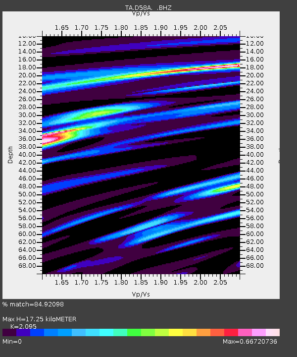
| Estimated Moho Depth: |
17.25 km |
| Estimated Crust Vp/Vs: |
2.10 |
| Assumed Crust Vp: |
6.61 km/s |
| Estimated Crust Vs: |
3.155 km/s |
| Estimated Crust Poisson's Ratio: |
0.35 |
|
| Radial Match: |
84.92098 % |
| Radial Bump: |
400 |
| Transverse Match: |
60.649136 % |
| Transverse Bump: |
400 |
| SOD ConfigId: |
626651 |
| Insert Time: |
2014-04-18 21:36:21.526 +0000 |
| GWidth: |
2.5 |
| Max Bumps: |
400 |
| Tol: |
0.001 |
|
Signal To Noise
| Channel | StoN | STA | LTA |
| TA:D58A: :BHZ:20130928T07:47:06.475024Z | 3.4125738 | 4.2241578E-7 | 1.2378217E-7 |
| TA:D58A: :BHN:20130928T07:47:06.475024Z | 1.4390601 | 1.6635609E-7 | 1.1560051E-7 |
| TA:D58A: :BHE:20130928T07:47:06.475024Z | 1.4482337 | 1.6112523E-7 | 1.1125638E-7 |
| Arrivals |
| Ps | 2.9 SECOND |
| PpPs | 7.9 SECOND |
| PsPs/PpSs | 11 SECOND |


