You are here: Home > Network List > TA - USArray Transportable Network (new EarthScope stations) Stations List
> Station I42A Draeger Farm, Ripon, WI, USA > Earthquake Result Viewer
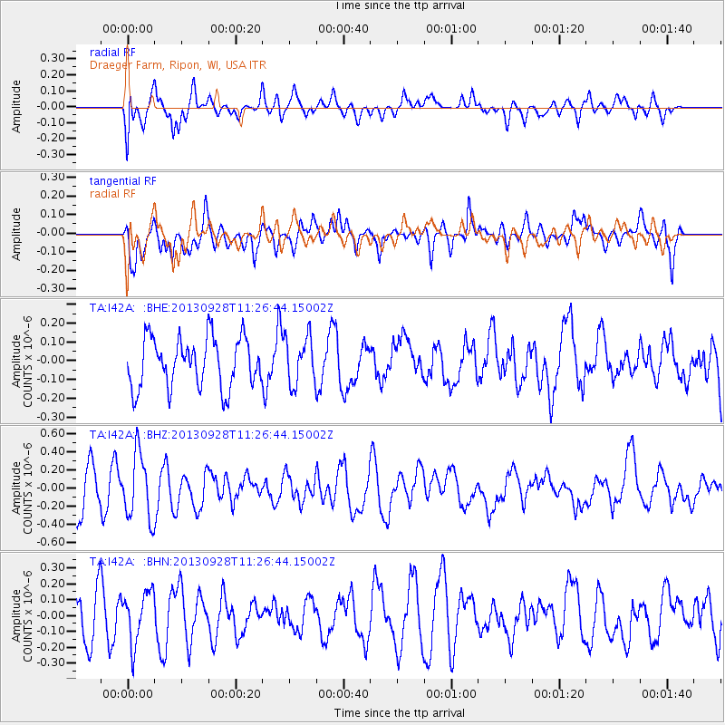
I42A Draeger Farm, Ripon, WI, USA - Earthquake Result Viewer
*The percent match for this event was below the threshold and hence no stack was calculated.
| Earthquake location: |
Tonga Islands |
| Earthquake latitude/longitude: |
-16.6/-173.8 |
| Earthquake time(UTC): |
2013/09/28 (271) 11:13:47 GMT |
| Earthquake Depth: |
59 km |
| Earthquake Magnitude: |
5.5 MWC, 5.5 MWC |
| Earthquake Catalog/Contributor: |
NEIC PDE/NEIC COMCAT |
|
| Network: |
TA USArray Transportable Network (new EarthScope stations) |
| Station: |
I42A Draeger Farm, Ripon, WI, USA |
| Lat/Lon: |
43.89 N/88.91 W |
| Elevation: |
298 m |
|
| Distance: |
97.7 deg |
| Az: |
46.613 deg |
| Baz: |
254.59 deg |
| Ray Param: |
$rayparam |
*The percent match for this event was below the threshold and hence was not used in the summary stack. |
|
| Radial Match: |
47.271435 % |
| Radial Bump: |
400 |
| Transverse Match: |
64.26499 % |
| Transverse Bump: |
400 |
| SOD ConfigId: |
626651 |
| Insert Time: |
2014-04-18 21:51:15.150 +0000 |
| GWidth: |
2.5 |
| Max Bumps: |
400 |
| Tol: |
0.001 |
|
Signal To Noise
| Channel | StoN | STA | LTA |
| TA:I42A: :BHZ:20130928T11:26:44.15002Z | 1.9737881 | 3.6628865E-7 | 1.8557647E-7 |
| TA:I42A: :BHN:20130928T11:26:44.15002Z | 1.0558462 | 1.6182527E-7 | 1.5326594E-7 |
| TA:I42A: :BHE:20130928T11:26:44.15002Z | 0.959522 | 1.262706E-7 | 1.315974E-7 |
| Arrivals |
| Ps | |
| PpPs | |
| PsPs/PpSs | |


