You are here: Home > Network List > AV - Alaska Volcano Observatory Stations List
> Station MAPS Pakushin Southeast, Makushin Volcano, Alaska > Earthquake Result Viewer
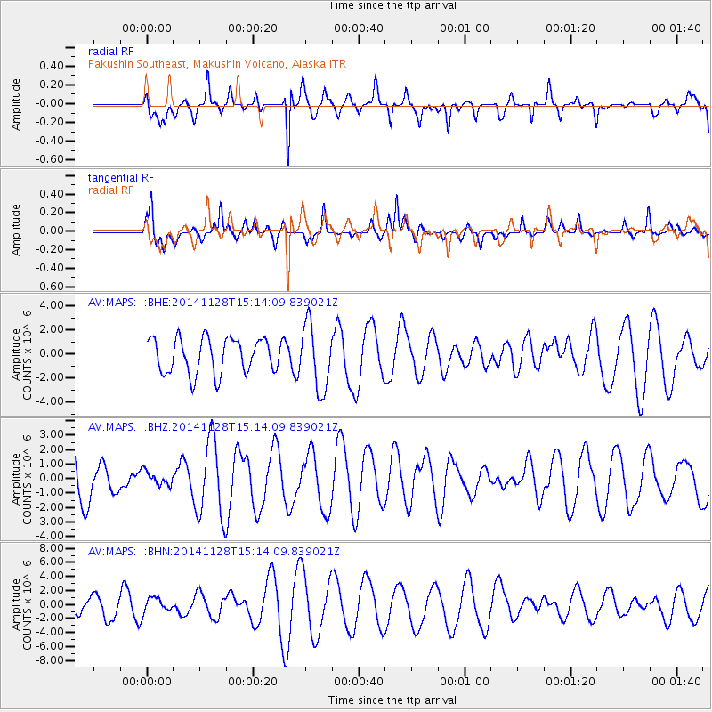
MAPS Pakushin Southeast, Makushin Volcano, Alaska - Earthquake Result Viewer
*The percent match for this event was below the threshold and hence no stack was calculated.
| Earthquake location: |
New Britain Region, P.N.G. |
| Earthquake latitude/longitude: |
-4.9/151.5 |
| Earthquake time(UTC): |
2014/11/28 (332) 15:03:57 GMT |
| Earthquake Depth: |
148 km |
| Earthquake Magnitude: |
5.2 MW, 5.1 mb |
| Earthquake Catalog/Contributor: |
ISC/ISC |
|
| Network: |
AV Alaska Volcano Observatory |
| Station: |
MAPS Pakushin Southeast, Makushin Volcano, Alaska |
| Lat/Lon: |
53.81 N/166.94 W |
| Elevation: |
333 m |
|
| Distance: |
68.0 deg |
| Az: |
25.1 deg |
| Baz: |
225.454 deg |
| Ray Param: |
$rayparam |
*The percent match for this event was below the threshold and hence was not used in the summary stack. |
|
| Radial Match: |
63.53289 % |
| Radial Bump: |
400 |
| Transverse Match: |
67.2852 % |
| Transverse Bump: |
400 |
| SOD ConfigId: |
3390531 |
| Insert Time: |
2019-04-15 05:36:42.091 +0000 |
| GWidth: |
2.5 |
| Max Bumps: |
400 |
| Tol: |
0.001 |
|
Signal To Noise
| Channel | StoN | STA | LTA |
| AV:MAPS: :BHZ:20141128T15:14:09.839021Z | 0.2779162 | 4.6398588E-7 | 1.6695174E-6 |
| AV:MAPS: :BHN:20141128T15:14:09.839021Z | 0.53654796 | 9.825021E-7 | 1.8311542E-6 |
| AV:MAPS: :BHE:20141128T15:14:09.839021Z | 1.8867486 | 2.7344854E-6 | 1.4493111E-6 |
| Arrivals |
| Ps | |
| PpPs | |
| PsPs/PpSs | |


