You are here: Home > Network List > US - United States National Seismic Network Stations List
> Station AMTX Amarillo, Texas, USA > Earthquake Result Viewer
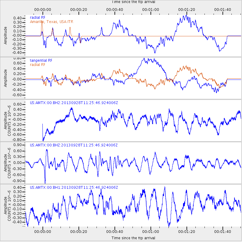
AMTX Amarillo, Texas, USA - Earthquake Result Viewer
*The percent match for this event was below the threshold and hence no stack was calculated.
| Earthquake location: |
Tonga Islands |
| Earthquake latitude/longitude: |
-16.6/-173.8 |
| Earthquake time(UTC): |
2013/09/28 (271) 11:13:47 GMT |
| Earthquake Depth: |
59 km |
| Earthquake Magnitude: |
5.5 MWC, 5.5 MWC |
| Earthquake Catalog/Contributor: |
NEIC PDE/NEIC COMCAT |
|
| Network: |
US United States National Seismic Network |
| Station: |
AMTX Amarillo, Texas, USA |
| Lat/Lon: |
34.53 N/101.41 W |
| Elevation: |
1010 m |
|
| Distance: |
85.5 deg |
| Az: |
52.145 deg |
| Baz: |
246.523 deg |
| Ray Param: |
$rayparam |
*The percent match for this event was below the threshold and hence was not used in the summary stack. |
|
| Radial Match: |
40.96195 % |
| Radial Bump: |
400 |
| Transverse Match: |
44.875107 % |
| Transverse Bump: |
400 |
| SOD ConfigId: |
626651 |
| Insert Time: |
2014-04-18 21:53:01.820 +0000 |
| GWidth: |
2.5 |
| Max Bumps: |
400 |
| Tol: |
0.001 |
|
Signal To Noise
| Channel | StoN | STA | LTA |
| US:AMTX:00:BHZ:20130928T11:25:46.924006Z | 2.621141 | 3.7745565E-7 | 1.4400433E-7 |
| US:AMTX:00:BH1:20130928T11:25:46.924006Z | 1.120156 | 5.8846155E-7 | 5.253389E-7 |
| US:AMTX:00:BH2:20130928T11:25:46.924006Z | 0.38094616 | 1.13501386E-7 | 2.97946E-7 |
| Arrivals |
| Ps | |
| PpPs | |
| PsPs/PpSs | |


