You are here: Home > Network List > US - United States National Seismic Network Stations List
> Station MNTX Cornudas Mountains, Texas, USA > Earthquake Result Viewer
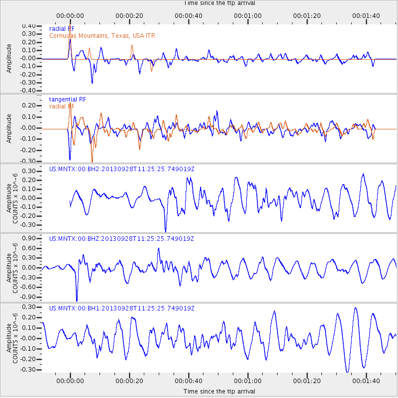
MNTX Cornudas Mountains, Texas, USA - Earthquake Result Viewer
*The percent match for this event was below the threshold and hence no stack was calculated.
| Earthquake location: |
Tonga Islands |
| Earthquake latitude/longitude: |
-16.6/-173.8 |
| Earthquake time(UTC): |
2013/09/28 (271) 11:13:47 GMT |
| Earthquake Depth: |
59 km |
| Earthquake Magnitude: |
5.5 MWC, 5.5 MWC |
| Earthquake Catalog/Contributor: |
NEIC PDE/NEIC COMCAT |
|
| Network: |
US United States National Seismic Network |
| Station: |
MNTX Cornudas Mountains, Texas, USA |
| Lat/Lon: |
31.70 N/105.38 W |
| Elevation: |
404 m |
|
| Distance: |
81.2 deg |
| Az: |
53.339 deg |
| Baz: |
244.5 deg |
| Ray Param: |
$rayparam |
*The percent match for this event was below the threshold and hence was not used in the summary stack. |
|
| Radial Match: |
80.15513 % |
| Radial Bump: |
400 |
| Transverse Match: |
57.538616 % |
| Transverse Bump: |
400 |
| SOD ConfigId: |
626651 |
| Insert Time: |
2014-04-18 21:53:41.277 +0000 |
| GWidth: |
2.5 |
| Max Bumps: |
400 |
| Tol: |
0.001 |
|
Signal To Noise
| Channel | StoN | STA | LTA |
| US:MNTX:00:BHZ:20130928T11:25:25.749019Z | 3.570176 | 3.34866E-7 | 9.379538E-8 |
| US:MNTX:00:BH1:20130928T11:25:25.749019Z | 0.41998535 | 3.7248313E-8 | 8.868955E-8 |
| US:MNTX:00:BH2:20130928T11:25:25.749019Z | 2.070008 | 1.3402567E-7 | 6.4746445E-8 |
| Arrivals |
| Ps | |
| PpPs | |
| PsPs/PpSs | |


