You are here: Home > Network List > UU - University of Utah Regional Network Stations List
> Station CCUT Cedar City, UT, USA > Earthquake Result Viewer
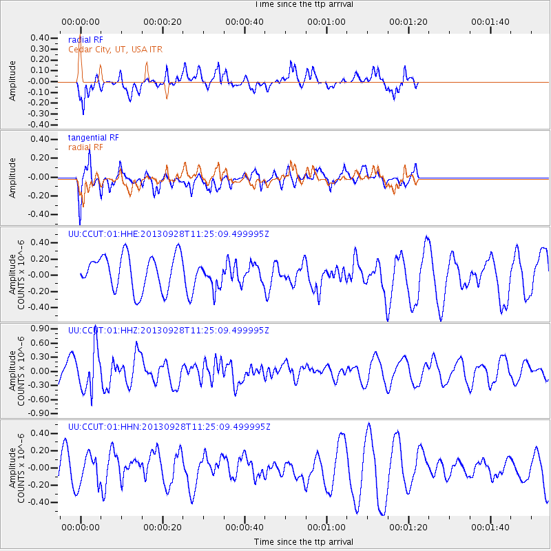
CCUT Cedar City, UT, USA - Earthquake Result Viewer
*The percent match for this event was below the threshold and hence no stack was calculated.
| Earthquake location: |
Tonga Islands |
| Earthquake latitude/longitude: |
-16.6/-173.8 |
| Earthquake time(UTC): |
2013/09/28 (271) 11:13:47 GMT |
| Earthquake Depth: |
59 km |
| Earthquake Magnitude: |
5.5 MWC, 5.5 MWC |
| Earthquake Catalog/Contributor: |
NEIC PDE/NEIC COMCAT |
|
| Network: |
UU University of Utah Regional Network |
| Station: |
CCUT Cedar City, UT, USA |
| Lat/Lon: |
37.55 N/113.36 W |
| Elevation: |
2127 m |
|
| Distance: |
78.2 deg |
| Az: |
44.943 deg |
| Baz: |
238.477 deg |
| Ray Param: |
$rayparam |
*The percent match for this event was below the threshold and hence was not used in the summary stack. |
|
| Radial Match: |
71.153336 % |
| Radial Bump: |
328 |
| Transverse Match: |
46.36445 % |
| Transverse Bump: |
400 |
| SOD ConfigId: |
626651 |
| Insert Time: |
2014-04-18 21:54:09.632 +0000 |
| GWidth: |
2.5 |
| Max Bumps: |
400 |
| Tol: |
0.001 |
|
Signal To Noise
| Channel | StoN | STA | LTA |
| UU:CCUT:01:HHZ:20130928T11:25:09.499995Z | 2.4573421 | 4.5896368E-7 | 1.8677241E-7 |
| UU:CCUT:01:HHN:20130928T11:25:09.499995Z | 1.2768335 | 1.7555948E-7 | 1.3749597E-7 |
| UU:CCUT:01:HHE:20130928T11:25:09.499995Z | 0.7359014 | 1.5727727E-7 | 2.1372058E-7 |
| Arrivals |
| Ps | |
| PpPs | |
| PsPs/PpSs | |


