You are here: Home > Network List > TA - USArray Transportable Network (new EarthScope stations) Stations List
> Station MSTX Muleshoe, TX, USA > Earthquake Result Viewer
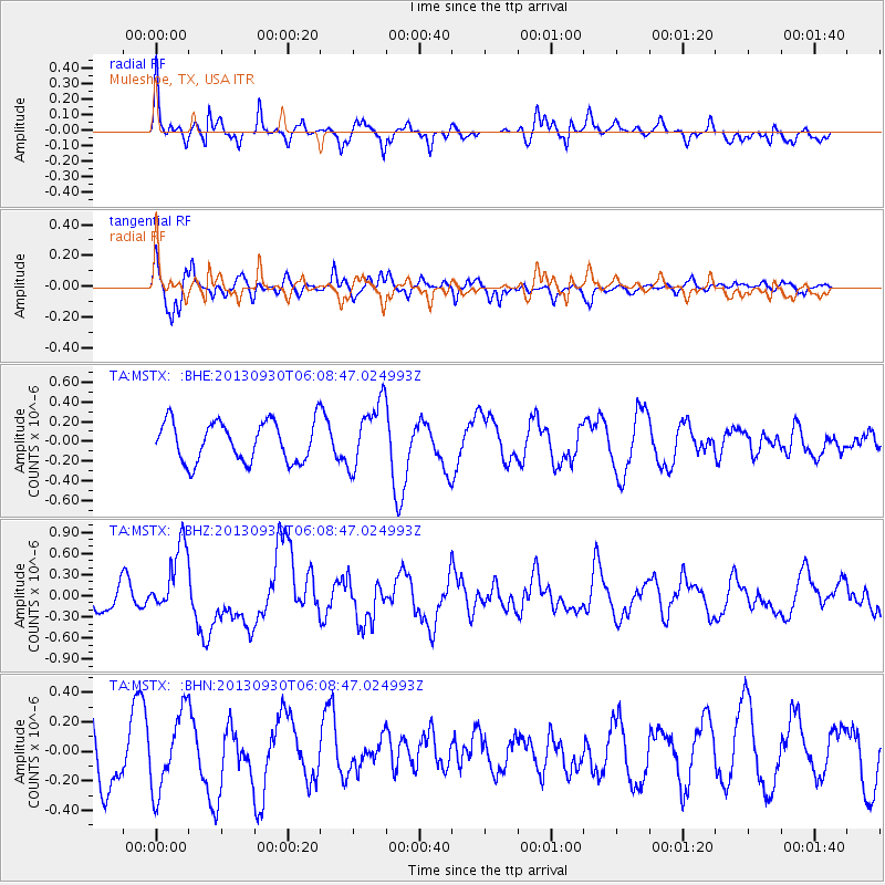
MSTX Muleshoe, TX, USA - Earthquake Result Viewer
*The percent match for this event was below the threshold and hence no stack was calculated.
| Earthquake location: |
Kermadec Islands, New Zealand |
| Earthquake latitude/longitude: |
-30.9/-178.3 |
| Earthquake time(UTC): |
2013/09/30 (273) 05:55:55 GMT |
| Earthquake Depth: |
42 km |
| Earthquake Magnitude: |
6.5 MWW, 6.4 MWC, 6.5 MWW, 6.5 MWB, 6.7 MI |
| Earthquake Catalog/Contributor: |
NEIC PDE/NEIC COMCAT |
|
| Network: |
TA USArray Transportable Network (new EarthScope stations) |
| Station: |
MSTX Muleshoe, TX, USA |
| Lat/Lon: |
33.97 N/102.77 W |
| Elevation: |
1167 m |
|
| Distance: |
96.1 deg |
| Az: |
54.033 deg |
| Baz: |
236.815 deg |
| Ray Param: |
$rayparam |
*The percent match for this event was below the threshold and hence was not used in the summary stack. |
|
| Radial Match: |
78.08817 % |
| Radial Bump: |
400 |
| Transverse Match: |
73.85741 % |
| Transverse Bump: |
397 |
| SOD ConfigId: |
626651 |
| Insert Time: |
2014-04-18 22:10:35.145 +0000 |
| GWidth: |
2.5 |
| Max Bumps: |
400 |
| Tol: |
0.001 |
|
Signal To Noise
| Channel | StoN | STA | LTA |
| TA:MSTX: :BHZ:20130930T06:08:47.024993Z | 2.5762503 | 4.961262E-7 | 1.9257685E-7 |
| TA:MSTX: :BHN:20130930T06:08:47.024993Z | 1.0658952 | 2.622372E-7 | 2.460253E-7 |
| TA:MSTX: :BHE:20130930T06:08:47.024993Z | 1.6393886 | 3.332537E-7 | 2.0327927E-7 |
| Arrivals |
| Ps | |
| PpPs | |
| PsPs/PpSs | |


