You are here: Home > Network List > US - United States National Seismic Network Stations List
> Station MNTX Cornudas Mountains, Texas, USA > Earthquake Result Viewer
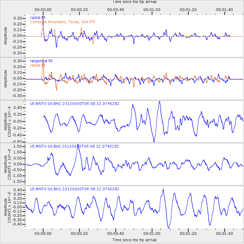
MNTX Cornudas Mountains, Texas, USA - Earthquake Result Viewer
*The percent match for this event was below the threshold and hence no stack was calculated.
| Earthquake location: |
Kermadec Islands, New Zealand |
| Earthquake latitude/longitude: |
-30.9/-178.3 |
| Earthquake time(UTC): |
2013/09/30 (273) 05:55:55 GMT |
| Earthquake Depth: |
42 km |
| Earthquake Magnitude: |
6.5 MWW, 6.4 MWC, 6.5 MWW, 6.5 MWB, 6.7 MI |
| Earthquake Catalog/Contributor: |
NEIC PDE/NEIC COMCAT |
|
| Network: |
US United States National Seismic Network |
| Station: |
MNTX Cornudas Mountains, Texas, USA |
| Lat/Lon: |
31.70 N/105.38 W |
| Elevation: |
404 m |
|
| Distance: |
93.0 deg |
| Az: |
54.688 deg |
| Baz: |
235.354 deg |
| Ray Param: |
$rayparam |
*The percent match for this event was below the threshold and hence was not used in the summary stack. |
|
| Radial Match: |
68.91772 % |
| Radial Bump: |
371 |
| Transverse Match: |
85.03359 % |
| Transverse Bump: |
400 |
| SOD ConfigId: |
626651 |
| Insert Time: |
2014-04-18 22:11:26.990 +0000 |
| GWidth: |
2.5 |
| Max Bumps: |
400 |
| Tol: |
0.001 |
|
Signal To Noise
| Channel | StoN | STA | LTA |
| US:MNTX:00:BHZ:20130930T06:08:32.974028Z | 4.0427246 | 4.5191302E-7 | 1.1178427E-7 |
| US:MNTX:00:BH1:20130930T06:08:32.974028Z | 1.1654738 | 8.333601E-8 | 7.1503976E-8 |
| US:MNTX:00:BH2:20130930T06:08:32.974028Z | 0.85502505 | 1.2155785E-7 | 1.4216876E-7 |
| Arrivals |
| Ps | |
| PpPs | |
| PsPs/PpSs | |


