You are here: Home > Network List > TA - USArray Transportable Network (new EarthScope stations) Stations List
> Station G40A Rib Lake, WI, USA > Earthquake Result Viewer
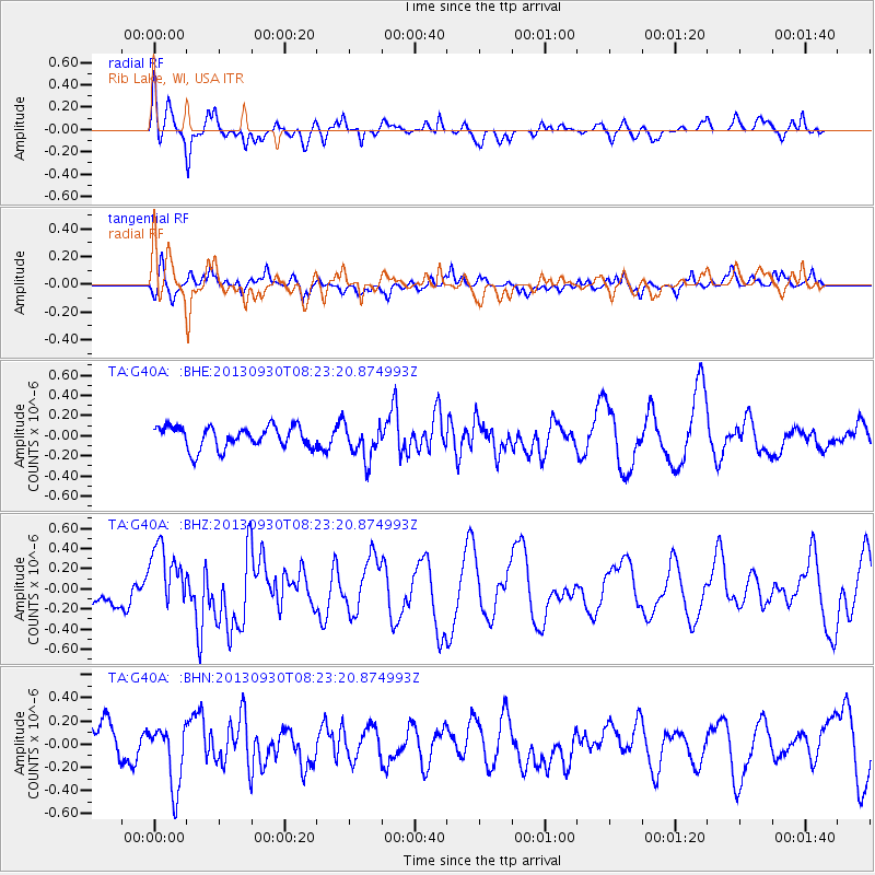
G40A Rib Lake, WI, USA - Earthquake Result Viewer
*The percent match for this event was below the threshold and hence no stack was calculated.
| Earthquake location: |
Northern Mid-Atlantic Ridge |
| Earthquake latitude/longitude: |
49.5/-28.5 |
| Earthquake time(UTC): |
2013/09/30 (273) 08:16:09 GMT |
| Earthquake Depth: |
10 km |
| Earthquake Magnitude: |
5.5 MWC, 5.5 MWC |
| Earthquake Catalog/Contributor: |
NEIC PDE/NEIC COMCAT |
|
| Network: |
TA USArray Transportable Network (new EarthScope stations) |
| Station: |
G40A Rib Lake, WI, USA |
| Lat/Lon: |
45.27 N/90.20 W |
| Elevation: |
472 m |
|
| Distance: |
40.9 deg |
| Az: |
288.471 deg |
| Baz: |
61.137 deg |
| Ray Param: |
$rayparam |
*The percent match for this event was below the threshold and hence was not used in the summary stack. |
|
| Radial Match: |
75.330574 % |
| Radial Bump: |
389 |
| Transverse Match: |
52.631966 % |
| Transverse Bump: |
400 |
| SOD ConfigId: |
626651 |
| Insert Time: |
2014-04-18 22:32:48.272 +0000 |
| GWidth: |
2.5 |
| Max Bumps: |
400 |
| Tol: |
0.001 |
|
Signal To Noise
| Channel | StoN | STA | LTA |
| TA:G40A: :BHZ:20130930T08:23:20.874993Z | 2.2793067 | 3.421217E-7 | 1.5009903E-7 |
| TA:G40A: :BHN:20130930T08:23:20.874993Z | 1.5318172 | 2.6729984E-7 | 1.7449852E-7 |
| TA:G40A: :BHE:20130930T08:23:20.874993Z | 1.6537523 | 1.798811E-7 | 1.0877149E-7 |
| Arrivals |
| Ps | |
| PpPs | |
| PsPs/PpSs | |


