You are here: Home > Network List > TA - USArray Transportable Network (new EarthScope stations) Stations List
> Station J62A Henniker, NH, USA > Earthquake Result Viewer
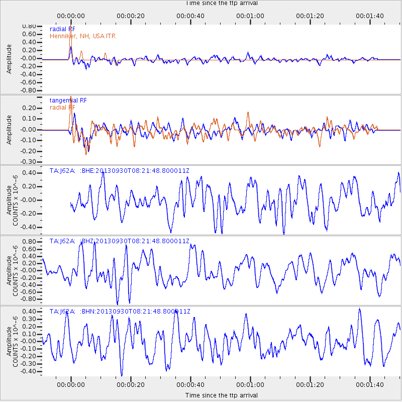
J62A Henniker, NH, USA - Earthquake Result Viewer
*The percent match for this event was below the threshold and hence no stack was calculated.
| Earthquake location: |
Northern Mid-Atlantic Ridge |
| Earthquake latitude/longitude: |
49.5/-28.5 |
| Earthquake time(UTC): |
2013/09/30 (273) 08:16:09 GMT |
| Earthquake Depth: |
10 km |
| Earthquake Magnitude: |
5.5 MWC, 5.5 MWC |
| Earthquake Catalog/Contributor: |
NEIC PDE/NEIC COMCAT |
|
| Network: |
TA USArray Transportable Network (new EarthScope stations) |
| Station: |
J62A Henniker, NH, USA |
| Lat/Lon: |
43.23 N/71.81 W |
| Elevation: |
266 m |
|
| Distance: |
30.2 deg |
| Az: |
274.741 deg |
| Baz: |
62.747 deg |
| Ray Param: |
$rayparam |
*The percent match for this event was below the threshold and hence was not used in the summary stack. |
|
| Radial Match: |
62.807568 % |
| Radial Bump: |
400 |
| Transverse Match: |
55.2527 % |
| Transverse Bump: |
400 |
| SOD ConfigId: |
626651 |
| Insert Time: |
2014-04-18 22:34:07.874 +0000 |
| GWidth: |
2.5 |
| Max Bumps: |
400 |
| Tol: |
0.001 |
|
Signal To Noise
| Channel | StoN | STA | LTA |
| TA:J62A: :BHZ:20130930T08:21:48.800011Z | 2.283208 | 4.1401958E-7 | 1.8133241E-7 |
| TA:J62A: :BHN:20130930T08:21:48.800011Z | 0.97025555 | 1.6869164E-7 | 1.7386311E-7 |
| TA:J62A: :BHE:20130930T08:21:48.800011Z | 1.522093 | 2.2762038E-7 | 1.4954432E-7 |
| Arrivals |
| Ps | |
| PpPs | |
| PsPs/PpSs | |


