You are here: Home > Network List > TA - USArray Transportable Network (new EarthScope stations) Stations List
> Station T52A Hallie, KY, USA > Earthquake Result Viewer
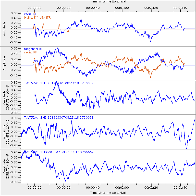
T52A Hallie, KY, USA - Earthquake Result Viewer
*The percent match for this event was below the threshold and hence no stack was calculated.
| Earthquake location: |
Northern Mid-Atlantic Ridge |
| Earthquake latitude/longitude: |
49.5/-28.5 |
| Earthquake time(UTC): |
2013/09/30 (273) 08:16:09 GMT |
| Earthquake Depth: |
10 km |
| Earthquake Magnitude: |
5.5 MWC, 5.5 MWC |
| Earthquake Catalog/Contributor: |
NEIC PDE/NEIC COMCAT |
|
| Network: |
TA USArray Transportable Network (new EarthScope stations) |
| Station: |
T52A Hallie, KY, USA |
| Lat/Lon: |
37.11 N/82.99 W |
| Elevation: |
436 m |
|
| Distance: |
40.7 deg |
| Az: |
273.464 deg |
| Baz: |
54.5 deg |
| Ray Param: |
$rayparam |
*The percent match for this event was below the threshold and hence was not used in the summary stack. |
|
| Radial Match: |
59.283855 % |
| Radial Bump: |
400 |
| Transverse Match: |
48.331966 % |
| Transverse Bump: |
400 |
| SOD ConfigId: |
626651 |
| Insert Time: |
2014-04-18 22:37:52.738 +0000 |
| GWidth: |
2.5 |
| Max Bumps: |
400 |
| Tol: |
0.001 |
|
Signal To Noise
| Channel | StoN | STA | LTA |
| TA:T52A: :BHZ:20130930T08:23:18.575005Z | 1.638106 | 3.1147349E-7 | 1.9014244E-7 |
| TA:T52A: :BHN:20130930T08:23:18.575005Z | 1.3977106 | 1.2307883E-6 | 8.805745E-7 |
| TA:T52A: :BHE:20130930T08:23:18.575005Z | 1.0604467 | 3.3614816E-7 | 3.1698733E-7 |
| Arrivals |
| Ps | |
| PpPs | |
| PsPs/PpSs | |


