You are here: Home > Network List > TJ - Tajikistan National Seismic Network Stations List
> Station GARM Garm, Tajikistan > Earthquake Result Viewer
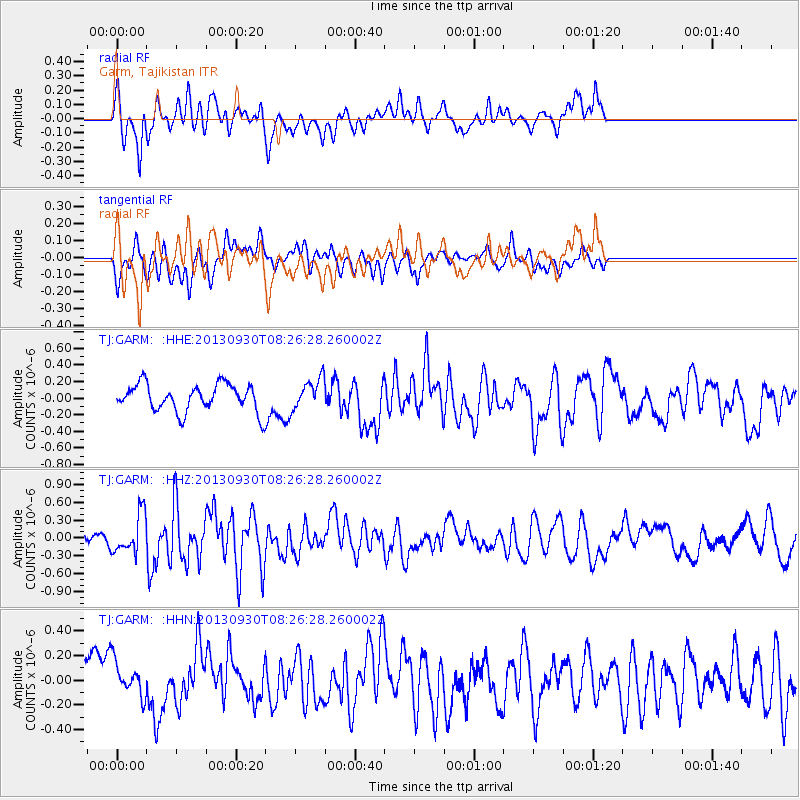
GARM Garm, Tajikistan - Earthquake Result Viewer
*The percent match for this event was below the threshold and hence no stack was calculated.
| Earthquake location: |
Northern Mid-Atlantic Ridge |
| Earthquake latitude/longitude: |
49.5/-28.5 |
| Earthquake time(UTC): |
2013/09/30 (273) 08:16:09 GMT |
| Earthquake Depth: |
10 km |
| Earthquake Magnitude: |
5.5 MWC, 5.5 MWC |
| Earthquake Catalog/Contributor: |
NEIC PDE/NEIC COMCAT |
|
| Network: |
TJ Tajikistan National Seismic Network |
| Station: |
GARM Garm, Tajikistan |
| Lat/Lon: |
39.00 N/70.32 E |
| Elevation: |
1305 m |
|
| Distance: |
66.6 deg |
| Az: |
57.028 deg |
| Baz: |
315.411 deg |
| Ray Param: |
$rayparam |
*The percent match for this event was below the threshold and hence was not used in the summary stack. |
|
| Radial Match: |
73.00112 % |
| Radial Bump: |
400 |
| Transverse Match: |
62.62888 % |
| Transverse Bump: |
400 |
| SOD ConfigId: |
626651 |
| Insert Time: |
2014-04-18 22:39:57.650 +0000 |
| GWidth: |
2.5 |
| Max Bumps: |
400 |
| Tol: |
0.001 |
|
Signal To Noise
| Channel | StoN | STA | LTA |
| TJ:GARM: :HHZ:20130930T08:26:28.260002Z | 2.2509334 | 3.2903873E-7 | 1.4617879E-7 |
| TJ:GARM: :HHN:20130930T08:26:28.260002Z | 1.0402012 | 1.4517968E-7 | 1.3956884E-7 |
| TJ:GARM: :HHE:20130930T08:26:28.260002Z | 1.1496191 | 1.8562925E-7 | 1.6147023E-7 |
| Arrivals |
| Ps | |
| PpPs | |
| PsPs/PpSs | |


