You are here: Home > Network List > AG - Arkansas Seismic Network Stations List
> Station LCAR Lake Charles,AR > Earthquake Result Viewer
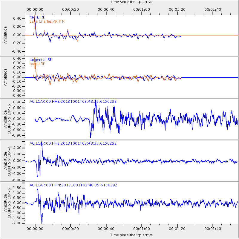
LCAR Lake Charles,AR - Earthquake Result Viewer

| Earthquake location: |
Sea Of Okhotsk |
| Earthquake latitude/longitude: |
53.2/152.8 |
| Earthquake time(UTC): |
2013/10/01 (274) 03:38:21 GMT |
| Earthquake Depth: |
573 km |
| Earthquake Magnitude: |
6.7 MWW, 6.7 MWC, 6.8 MWC, 6.8 MWB |
| Earthquake Catalog/Contributor: |
NEIC PDE/NEIC COMCAT |
|
| Network: |
AG Arkansas Seismic Network |
| Station: |
LCAR Lake Charles,AR |
| Lat/Lon: |
36.07 N/91.15 W |
| Elevation: |
103 m |
|
| Distance: |
75.3 deg |
| Az: |
48.809 deg |
| Baz: |
326.028 deg |
| Ray Param: |
0.049927276 |
| Estimated Moho Depth: |
45.75 km |
| Estimated Crust Vp/Vs: |
1.74 |
| Assumed Crust Vp: |
6.53 km/s |
| Estimated Crust Vs: |
3.764 km/s |
| Estimated Crust Poisson's Ratio: |
0.25 |
|
| Radial Match: |
84.95593 % |
| Radial Bump: |
400 |
| Transverse Match: |
69.453964 % |
| Transverse Bump: |
400 |
| SOD ConfigId: |
626651 |
| Insert Time: |
2014-04-18 22:44:31.711 +0000 |
| GWidth: |
2.5 |
| Max Bumps: |
400 |
| Tol: |
0.001 |
|
Signal To Noise
| Channel | StoN | STA | LTA |
| AG:LCAR:00:HHZ:20131001T03:48:35.615029Z | 16.203775 | 2.6851749E-6 | 1.657129E-7 |
| AG:LCAR:00:HHN:20131001T03:48:35.615029Z | 10.29349 | 8.335499E-7 | 8.097835E-8 |
| AG:LCAR:00:HHE:20131001T03:48:35.615029Z | 6.288423 | 4.889296E-7 | 7.775075E-8 |
| Arrivals |
| Ps | 5.3 SECOND |
| PpPs | 19 SECOND |
| PsPs/PpSs | 24 SECOND |


