You are here: Home > Network List > AK - Alaska Regional Network Stations List
> Station FYU Fort Yukon, Alaska, USA > Earthquake Result Viewer
FYU Fort Yukon, Alaska, USA - Earthquake Result Viewer
| Earthquake location: |
Sea Of Okhotsk |
| Earthquake latitude/longitude: |
53.2/152.8 |
| Earthquake time(UTC): |
2013/10/01 (274) 03:38:21 GMT |
| Earthquake Depth: |
573 km |
| Earthquake Magnitude: |
6.7 MWW, 6.7 MWC, 6.8 MWC, 6.8 MWB |
| Earthquake Catalog/Contributor: |
NEIC PDE/NEIC COMCAT |
|
| Network: |
AK Alaska Regional Network |
| Station: |
FYU Fort Yukon, Alaska, USA |
| Lat/Lon: |
66.57 N/145.23 W |
| Elevation: |
137 m |
|
| Distance: |
32.3 deg |
| Az: |
41.34 deg |
| Baz: |
276.494 deg |
| Ray Param: |
0.07602509 |
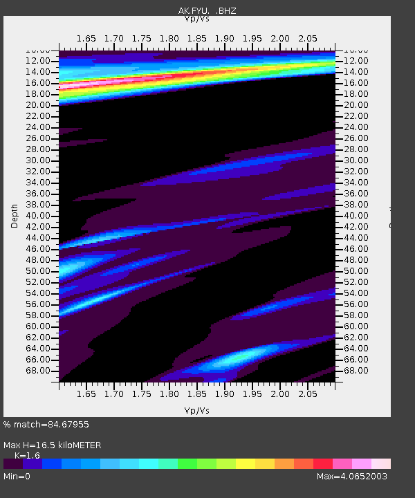
| Estimated Moho Depth: |
16.5 km |
| Estimated Crust Vp/Vs: |
1.60 |
| Assumed Crust Vp: |
6.522 km/s |
| Estimated Crust Vs: |
4.076 km/s |
| Estimated Crust Poisson's Ratio: |
0.18 |
|
| Radial Match: |
84.67955 % |
| Radial Bump: |
272 |
| Transverse Match: |
66.66533 % |
| Transverse Bump: |
400 |
| SOD ConfigId: |
626651 |
| Insert Time: |
2014-04-18 22:45:37.107 +0000 |
| GWidth: |
2.5 |
| Max Bumps: |
400 |
| Tol: |
0.001 |
|

Signal To Noise
| Channel | StoN | STA | LTA |
| AK:FYU: :BHZ:20131001T03:43:34.048013Z | 64.290054 | 1.5317073E-5 | 2.3824951E-7 |
| AK:FYU: :BHN:20131001T03:43:34.048013Z | 3.4884672 | 3.0736205E-6 | 8.8108055E-7 |
| AK:FYU: :BHE:20131001T03:43:34.048013Z | 11.821646 | 7.868938E-6 | 6.656382E-7 |
| Arrivals |
| Ps | 1.7 SECOND |
| PpPs | 6.0 SECOND |
| PsPs/PpSs | 7.7 SECOND |


