You are here: Home > Network List > BE - Belgian Seismic Network Stations List
> Station MEM Membach, Belgium > Earthquake Result Viewer
MEM Membach, Belgium - Earthquake Result Viewer
| Earthquake location: |
Sea Of Okhotsk |
| Earthquake latitude/longitude: |
53.2/152.8 |
| Earthquake time(UTC): |
2013/10/01 (274) 03:38:21 GMT |
| Earthquake Depth: |
573 km |
| Earthquake Magnitude: |
6.7 MWW, 6.7 MWC, 6.8 MWC, 6.8 MWB |
| Earthquake Catalog/Contributor: |
NEIC PDE/NEIC COMCAT |
|
| Network: |
BE Belgian Seismic Network |
| Station: |
MEM Membach, Belgium |
| Lat/Lon: |
50.61 N/6.01 E |
| Elevation: |
250 m |
|
| Distance: |
72.8 deg |
| Az: |
338.572 deg |
| Baz: |
20.179 deg |
| Ray Param: |
0.051495403 |
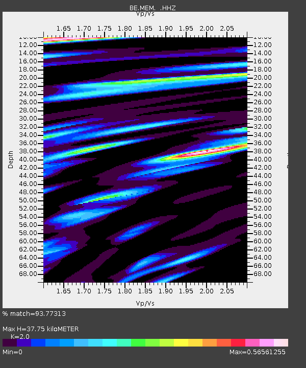
| Estimated Moho Depth: |
37.75 km |
| Estimated Crust Vp/Vs: |
2.00 |
| Assumed Crust Vp: |
6.276 km/s |
| Estimated Crust Vs: |
3.138 km/s |
| Estimated Crust Poisson's Ratio: |
0.33 |
|
| Radial Match: |
93.77313 % |
| Radial Bump: |
338 |
| Transverse Match: |
71.57282 % |
| Transverse Bump: |
400 |
| SOD ConfigId: |
626651 |
| Insert Time: |
2014-04-18 22:50:26.054 +0000 |
| GWidth: |
2.5 |
| Max Bumps: |
400 |
| Tol: |
0.001 |
|

Signal To Noise
| Channel | StoN | STA | LTA |
| BE:MEM: :HHZ:20131001T03:48:21.918008Z | 116.36796 | 1.0201778E-5 | 8.7668276E-8 |
| BE:MEM: :HHN:20131001T03:48:21.918008Z | 36.308777 | 4.2421557E-6 | 1.16835544E-7 |
| BE:MEM: :HHE:20131001T03:48:21.918008Z | 14.340232 | 1.6339054E-6 | 1.13938555E-7 |
| Arrivals |
| Ps | 6.2 SECOND |
| PpPs | 18 SECOND |
| PsPs/PpSs | 24 SECOND |


