You are here: Home > Network List > CN - Canadian National Seismograph Network Stations List
> Station VLDQ VALDOR, QC > Earthquake Result Viewer
VLDQ VALDOR, QC - Earthquake Result Viewer
| Earthquake location: |
Sea Of Okhotsk |
| Earthquake latitude/longitude: |
53.2/152.8 |
| Earthquake time(UTC): |
2013/10/01 (274) 03:38:21 GMT |
| Earthquake Depth: |
573 km |
| Earthquake Magnitude: |
6.7 MWW, 6.7 MWC, 6.8 MWC, 6.8 MWB |
| Earthquake Catalog/Contributor: |
NEIC PDE/NEIC COMCAT |
|
| Network: |
CN Canadian National Seismograph Network |
| Station: |
VLDQ VALDOR, QC |
| Lat/Lon: |
48.19 N/77.76 W |
| Elevation: |
93 m |
|
| Distance: |
70.3 deg |
| Az: |
33.293 deg |
| Baz: |
330.428 deg |
| Ray Param: |
0.053140257 |
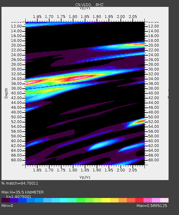
| Estimated Moho Depth: |
35.5 km |
| Estimated Crust Vp/Vs: |
1.61 |
| Assumed Crust Vp: |
6.61 km/s |
| Estimated Crust Vs: |
4.112 km/s |
| Estimated Crust Poisson's Ratio: |
0.18 |
|
| Radial Match: |
84.70011 % |
| Radial Bump: |
400 |
| Transverse Match: |
59.088436 % |
| Transverse Bump: |
400 |
| SOD ConfigId: |
626651 |
| Insert Time: |
2014-04-18 22:54:48.256 +0000 |
| GWidth: |
2.5 |
| Max Bumps: |
400 |
| Tol: |
0.001 |
|

Signal To Noise
| Channel | StoN | STA | LTA |
| CN:VLDQ: :BHZ:20131001T03:48:06.94999Z | 39.81297 | 5.6182525E-6 | 1.4111613E-7 |
| CN:VLDQ: :BHN:20131001T03:48:06.94999Z | 11.673157 | 1.9472093E-6 | 1.6681085E-7 |
| CN:VLDQ: :BHE:20131001T03:48:06.94999Z | 6.2754107 | 1.1791809E-6 | 1.8790497E-7 |
| Arrivals |
| Ps | 3.4 SECOND |
| PpPs | 13 SECOND |
| PsPs/PpSs | 17 SECOND |


