You are here: Home > Network List > GE - GEOFON Stations List
> Station VSU GEOFON Station Vasula, Estonia > Earthquake Result Viewer
VSU GEOFON Station Vasula, Estonia - Earthquake Result Viewer
| Earthquake location: |
Sea Of Okhotsk |
| Earthquake latitude/longitude: |
53.2/152.8 |
| Earthquake time(UTC): |
2013/10/01 (274) 03:38:21 GMT |
| Earthquake Depth: |
573 km |
| Earthquake Magnitude: |
6.7 MWW, 6.7 MWC, 6.8 MWC, 6.8 MWB |
| Earthquake Catalog/Contributor: |
NEIC PDE/NEIC COMCAT |
|
| Network: |
GE GEOFON |
| Station: |
VSU GEOFON Station Vasula, Estonia |
| Lat/Lon: |
58.46 N/26.73 E |
| Elevation: |
63 m |
|
| Distance: |
60.4 deg |
| Az: |
330.753 deg |
| Baz: |
34.002 deg |
| Ray Param: |
0.059278507 |
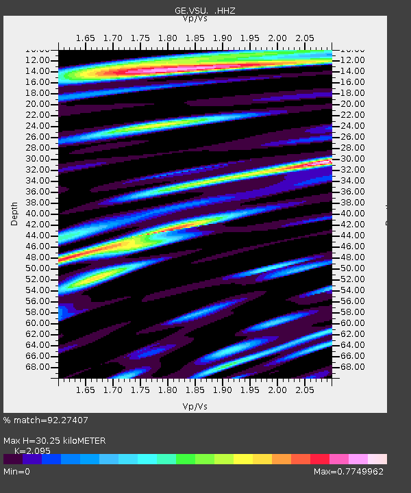
| Estimated Moho Depth: |
30.25 km |
| Estimated Crust Vp/Vs: |
2.10 |
| Assumed Crust Vp: |
6.552 km/s |
| Estimated Crust Vs: |
3.128 km/s |
| Estimated Crust Poisson's Ratio: |
0.35 |
|
| Radial Match: |
92.27407 % |
| Radial Bump: |
377 |
| Transverse Match: |
67.90954 % |
| Transverse Bump: |
400 |
| SOD ConfigId: |
626651 |
| Insert Time: |
2014-04-18 22:57:54.253 +0000 |
| GWidth: |
2.5 |
| Max Bumps: |
400 |
| Tol: |
0.001 |
|

Signal To Noise
| Channel | StoN | STA | LTA |
| GE:VSU: :HHZ:20131001T03:47:05.710Z | 96.440414 | 4.491084E-5 | 4.6568485E-7 |
| GE:VSU: :HHN:20131001T03:47:05.710Z | 34.707085 | 1.9509978E-5 | 5.6213247E-7 |
| GE:VSU: :HHE:20131001T03:47:05.710Z | 32.589767 | 1.5650536E-5 | 4.8022855E-7 |
| Arrivals |
| Ps | 5.2 SECOND |
| PpPs | 14 SECOND |
| PsPs/PpSs | 19 SECOND |


