You are here: Home > Network List > IW - Intermountain West Stations List
> Station DLMT Dillon, Montana, USA > Earthquake Result Viewer
DLMT Dillon, Montana, USA - Earthquake Result Viewer
*The percent match for this event was below the threshold and hence no stack was calculated.
| Earthquake location: |
Sea Of Okhotsk |
| Earthquake latitude/longitude: |
53.2/152.8 |
| Earthquake time(UTC): |
2013/10/01 (274) 03:38:21 GMT |
| Earthquake Depth: |
573 km |
| Earthquake Magnitude: |
6.7 MWW, 6.7 MWC, 6.8 MWC, 6.8 MWB |
| Earthquake Catalog/Contributor: |
NEIC PDE/NEIC COMCAT |
|
| Network: |
IW Intermountain West |
| Station: |
DLMT Dillon, Montana, USA |
| Lat/Lon: |
45.36 N/112.60 W |
| Elevation: |
1569 m |
|
| Distance: |
57.8 deg |
| Az: |
56.112 deg |
| Baz: |
314.897 deg |
| Ray Param: |
$rayparam |
*The percent match for this event was below the threshold and hence was not used in the summary stack. |
|
| Radial Match: |
57.84366 % |
| Radial Bump: |
400 |
| Transverse Match: |
67.19886 % |
| Transverse Bump: |
400 |
| SOD ConfigId: |
626651 |
| Insert Time: |
2014-04-18 23:02:48.224 +0000 |
| GWidth: |
2.5 |
| Max Bumps: |
400 |
| Tol: |
0.001 |
|
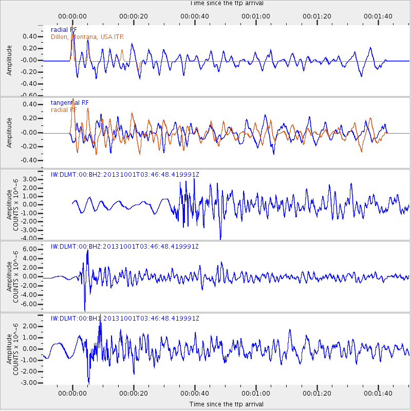
Signal To Noise
| Channel | StoN | STA | LTA |
| IW:DLMT:00:BHZ:20131001T03:46:48.419991Z | 10.344801 | 1.969223E-6 | 1.903587E-7 |
| IW:DLMT:00:BH1:20131001T03:46:48.419991Z | 1.2160926 | 6.9890325E-7 | 5.747122E-7 |
| IW:DLMT:00:BH2:20131001T03:46:48.419991Z | 1.8872473 | 7.865594E-7 | 4.1677598E-7 |
| Arrivals |
| Ps | |
| PpPs | |
| PsPs/PpSs | |


