You are here: Home > Network List > IW - Intermountain West Stations List
> Station IMW Indian Meadow, Wyoming, USA > Earthquake Result Viewer
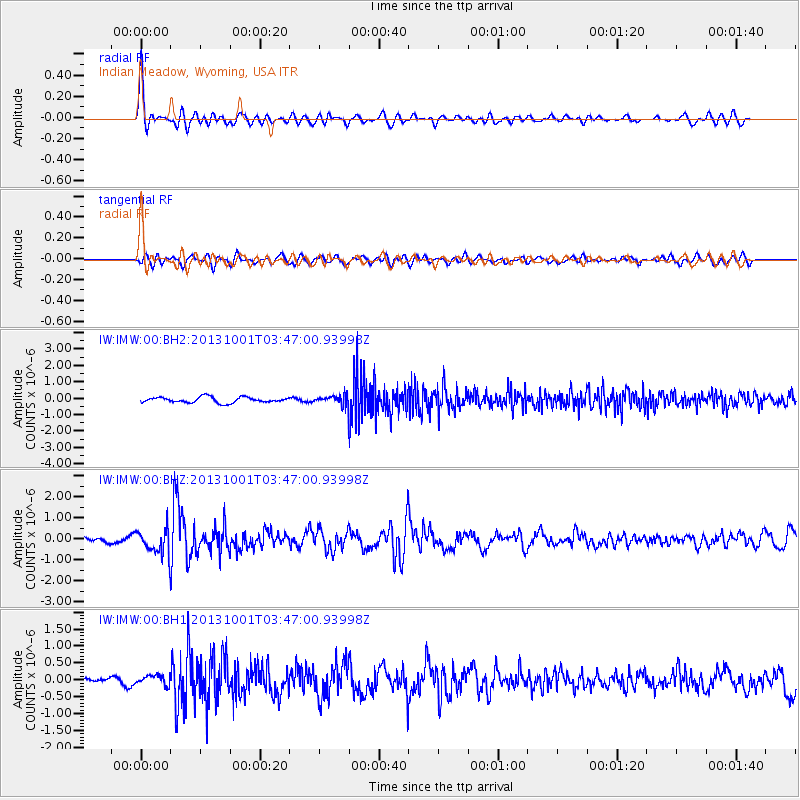
IMW Indian Meadow, Wyoming, USA - Earthquake Result Viewer
*The percent match for this event was below the threshold and hence no stack was calculated.
| Earthquake location: |
Sea Of Okhotsk |
| Earthquake latitude/longitude: |
53.2/152.8 |
| Earthquake time(UTC): |
2013/10/01 (274) 03:38:21 GMT |
| Earthquake Depth: |
573 km |
| Earthquake Magnitude: |
6.7 MWW, 6.7 MWC, 6.8 MWC, 6.8 MWB |
| Earthquake Catalog/Contributor: |
NEIC PDE/NEIC COMCAT |
|
| Network: |
IW Intermountain West |
| Station: |
IMW Indian Meadow, Wyoming, USA |
| Lat/Lon: |
43.90 N/110.94 W |
| Elevation: |
2646 m |
|
| Distance: |
59.7 deg |
| Az: |
56.325 deg |
| Baz: |
316.167 deg |
| Ray Param: |
$rayparam |
*The percent match for this event was below the threshold and hence was not used in the summary stack. |
|
| Radial Match: |
63.469658 % |
| Radial Bump: |
400 |
| Transverse Match: |
46.595707 % |
| Transverse Bump: |
400 |
| SOD ConfigId: |
626651 |
| Insert Time: |
2014-04-18 23:02:56.094 +0000 |
| GWidth: |
2.5 |
| Max Bumps: |
400 |
| Tol: |
0.001 |
|
Signal To Noise
| Channel | StoN | STA | LTA |
| IW:IMW:00:BHZ:20131001T03:47:00.93998Z | 3.4244833 | 5.90557E-7 | 1.7245142E-7 |
| IW:IMW:00:BH1:20131001T03:47:00.93998Z | 0.7103977 | 1.4633032E-7 | 2.0598367E-7 |
| IW:IMW:00:BH2:20131001T03:47:00.93998Z | 1.5954274 | 2.6936308E-7 | 1.6883443E-7 |
| Arrivals |
| Ps | |
| PpPs | |
| PsPs/PpSs | |


