You are here: Home > Network List > PE - Penn State Network Stations List
> Station WRPS We R Penn State > Earthquake Result Viewer
WRPS We R Penn State - Earthquake Result Viewer
| Earthquake location: |
Sea Of Okhotsk |
| Earthquake latitude/longitude: |
53.2/152.8 |
| Earthquake time(UTC): |
2013/10/01 (274) 03:38:21 GMT |
| Earthquake Depth: |
573 km |
| Earthquake Magnitude: |
6.7 MWW, 6.7 MWC, 6.8 MWC, 6.8 MWB |
| Earthquake Catalog/Contributor: |
NEIC PDE/NEIC COMCAT |
|
| Network: |
PE Penn State Network |
| Station: |
WRPS We R Penn State |
| Lat/Lon: |
40.79 N/77.87 W |
| Elevation: |
320 m |
|
| Distance: |
76.7 deg |
| Az: |
37.109 deg |
| Baz: |
331.44 deg |
| Ray Param: |
0.049012344 |
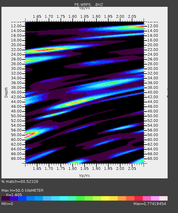
| Estimated Moho Depth: |
58.0 km |
| Estimated Crust Vp/Vs: |
1.61 |
| Assumed Crust Vp: |
6.121 km/s |
| Estimated Crust Vs: |
3.813 km/s |
| Estimated Crust Poisson's Ratio: |
0.18 |
|
| Radial Match: |
80.52328 % |
| Radial Bump: |
400 |
| Transverse Match: |
55.970444 % |
| Transverse Bump: |
400 |
| SOD ConfigId: |
626651 |
| Insert Time: |
2014-04-18 23:09:46.943 +0000 |
| GWidth: |
2.5 |
| Max Bumps: |
400 |
| Tol: |
0.001 |
|
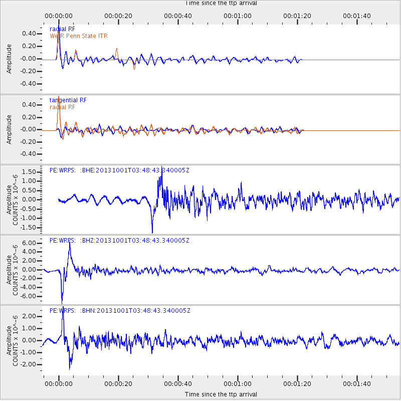
Signal To Noise
| Channel | StoN | STA | LTA |
| PE:WRPS: :BHZ:20131001T03:48:43.340005Z | 16.516512 | 3.0029971E-6 | 1.8181788E-7 |
| PE:WRPS: :BHN:20131001T03:48:43.340005Z | 6.8055916 | 1.0878238E-6 | 1.5984266E-7 |
| PE:WRPS: :BHE:20131001T03:48:43.340005Z | 5.824814 | 7.435479E-7 | 1.2765179E-7 |
| Arrivals |
| Ps | 5.9 SECOND |
| PpPs | 24 SECOND |
| PsPs/PpSs | 30 SECOND |


