You are here: Home > Network List > TA - USArray Transportable Network (new EarthScope stations) Stations List
> Station 058A Arcadia, FL, USA > Earthquake Result Viewer
058A Arcadia, FL, USA - Earthquake Result Viewer

| Earthquake location: |
Sea Of Okhotsk |
| Earthquake latitude/longitude: |
53.2/152.8 |
| Earthquake time(UTC): |
2013/10/01 (274) 03:38:21 GMT |
| Earthquake Depth: |
573 km |
| Earthquake Magnitude: |
6.7 MWW, 6.7 MWC, 6.8 MWC, 6.8 MWB |
| Earthquake Catalog/Contributor: |
NEIC PDE/NEIC COMCAT |
|
| Network: |
TA USArray Transportable Network (new EarthScope stations) |
| Station: |
058A Arcadia, FL, USA |
| Lat/Lon: |
27.06 N/81.80 W |
| Elevation: |
15 m |
|
| Distance: |
87.1 deg |
| Az: |
46.7 deg |
| Baz: |
330.596 deg |
| Ray Param: |
0.041940898 |
| Estimated Moho Depth: |
16.5 km |
| Estimated Crust Vp/Vs: |
1.67 |
| Assumed Crust Vp: |
6.347 km/s |
| Estimated Crust Vs: |
3.806 km/s |
| Estimated Crust Poisson's Ratio: |
0.22 |
|
| Radial Match: |
86.441414 % |
| Radial Bump: |
400 |
| Transverse Match: |
67.9435 % |
| Transverse Bump: |
400 |
| SOD ConfigId: |
626651 |
| Insert Time: |
2014-04-18 23:13:39.029 +0000 |
| GWidth: |
2.5 |
| Max Bumps: |
400 |
| Tol: |
0.001 |
|
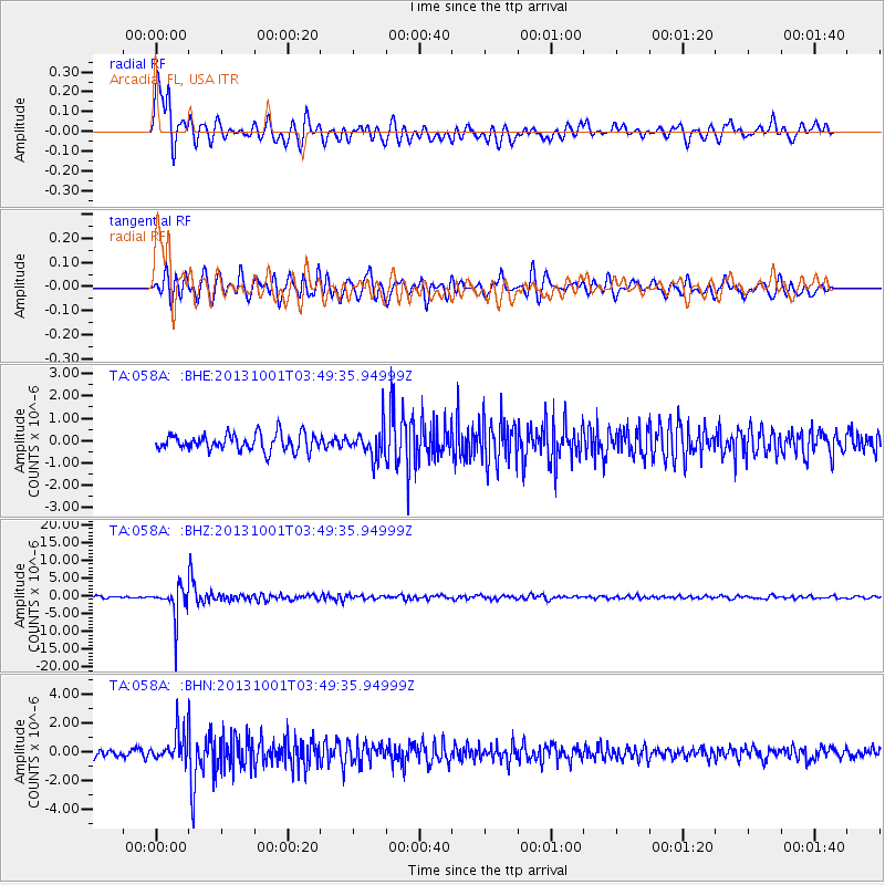
Signal To Noise
| Channel | StoN | STA | LTA |
| TA:058A: :BHZ:20131001T03:49:35.94999Z | 14.238624 | 4.5312963E-6 | 3.1823978E-7 |
| TA:058A: :BHN:20131001T03:49:35.94999Z | 4.2003937 | 1.0143309E-6 | 2.414847E-7 |
| TA:058A: :BHE:20131001T03:49:35.94999Z | 1.7030478 | 6.3975057E-7 | 3.7565042E-7 |
| Arrivals |
| Ps | 1.8 SECOND |
| PpPs | 6.8 SECOND |
| PsPs/PpSs | 8.6 SECOND |


