You are here: Home > Network List > TA - USArray Transportable Network (new EarthScope stations) Stations List
> Station 859A Kempfer Cattle CO., St. Cloud, FL, USA > Earthquake Result Viewer
859A Kempfer Cattle CO., St. Cloud, FL, USA - Earthquake Result Viewer
| Earthquake location: |
Sea Of Okhotsk |
| Earthquake latitude/longitude: |
53.2/152.8 |
| Earthquake time(UTC): |
2013/10/01 (274) 03:38:21 GMT |
| Earthquake Depth: |
573 km |
| Earthquake Magnitude: |
6.7 MWW, 6.7 MWC, 6.8 MWC, 6.8 MWB |
| Earthquake Catalog/Contributor: |
NEIC PDE/NEIC COMCAT |
|
| Network: |
TA USArray Transportable Network (new EarthScope stations) |
| Station: |
859A Kempfer Cattle CO., St. Cloud, FL, USA |
| Lat/Lon: |
28.06 N/80.90 W |
| Elevation: |
13 m |
|
| Distance: |
86.6 deg |
| Az: |
45.508 deg |
| Baz: |
330.948 deg |
| Ray Param: |
0.042274676 |
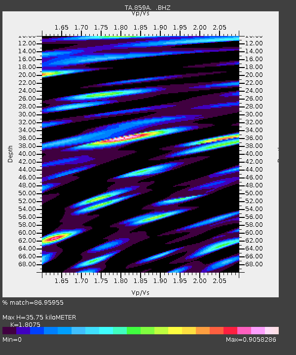
| Estimated Moho Depth: |
35.75 km |
| Estimated Crust Vp/Vs: |
1.81 |
| Assumed Crust Vp: |
6.134 km/s |
| Estimated Crust Vs: |
3.394 km/s |
| Estimated Crust Poisson's Ratio: |
0.28 |
|
| Radial Match: |
86.95955 % |
| Radial Bump: |
400 |
| Transverse Match: |
73.29113 % |
| Transverse Bump: |
400 |
| SOD ConfigId: |
626651 |
| Insert Time: |
2014-04-18 23:15:21.632 +0000 |
| GWidth: |
2.5 |
| Max Bumps: |
400 |
| Tol: |
0.001 |
|
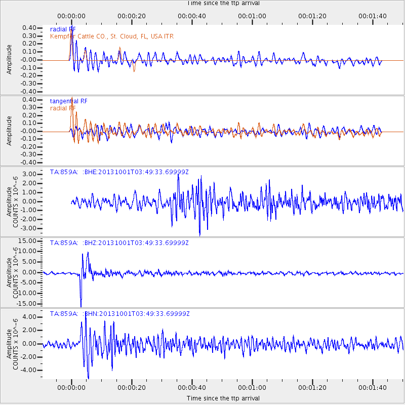
Signal To Noise
| Channel | StoN | STA | LTA |
| TA:859A: :BHZ:20131001T03:49:33.69999Z | 13.611738 | 4.3165005E-6 | 3.1711605E-7 |
| TA:859A: :BHN:20131001T03:49:33.69999Z | 5.7617226 | 1.5713694E-6 | 2.7272563E-7 |
| TA:859A: :BHE:20131001T03:49:33.69999Z | 1.8777418 | 8.667893E-7 | 4.6161264E-7 |
| Arrivals |
| Ps | 4.8 SECOND |
| PpPs | 16 SECOND |
| PsPs/PpSs | 21 SECOND |


