You are here: Home > Network List > PF - Volcanologic Network of Piton de Fournaise-OVPF Stations List
> Station HIM cratere Himiltrude > Earthquake Result Viewer
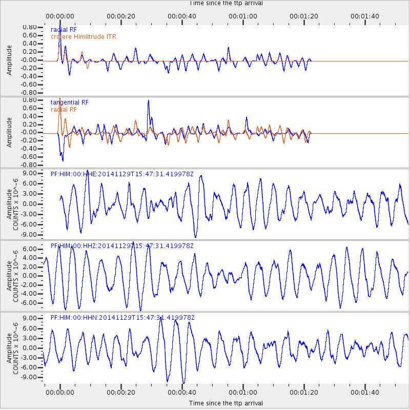
HIM cratere Himiltrude - Earthquake Result Viewer
*The percent match for this event was below the threshold and hence no stack was calculated.
| Earthquake location: |
Philippine Islands Region |
| Earthquake latitude/longitude: |
19.9/121.4 |
| Earthquake time(UTC): |
2014/11/29 (333) 15:36:17 GMT |
| Earthquake Depth: |
34 km |
| Earthquake Magnitude: |
5.3 MW, 4.6 MS, 5.2 mb |
| Earthquake Catalog/Contributor: |
ISC/ISC |
|
| Network: |
PF Volcanologic Network of Piton de Fournaise-OVPF |
| Station: |
HIM cratere Himiltrude |
| Lat/Lon: |
21.21 S/55.72 E |
| Elevation: |
1958 m |
|
| Distance: |
76.1 deg |
| Az: |
241.163 deg |
| Baz: |
62.067 deg |
| Ray Param: |
$rayparam |
*The percent match for this event was below the threshold and hence was not used in the summary stack. |
|
| Radial Match: |
79.604744 % |
| Radial Bump: |
400 |
| Transverse Match: |
67.215744 % |
| Transverse Bump: |
400 |
| SOD ConfigId: |
3390531 |
| Insert Time: |
2019-04-15 06:07:06.712 +0000 |
| GWidth: |
2.5 |
| Max Bumps: |
400 |
| Tol: |
0.001 |
|
Signal To Noise
| Channel | StoN | STA | LTA |
| PF:HIM:00:HHZ:20141129T15:47:31.419978Z | 1.9570314 | 5.1675356E-6 | 2.640497E-6 |
| PF:HIM:00:HHN:20141129T15:47:31.419978Z | 1.377278 | 3.8665075E-6 | 2.8073546E-6 |
| PF:HIM:00:HHE:20141129T15:47:31.419978Z | 0.3848936 | 1.4216456E-6 | 3.693607E-6 |
| Arrivals |
| Ps | |
| PpPs | |
| PsPs/PpSs | |


