You are here: Home > Network List > TA - USArray Transportable Network (new EarthScope stations) Stations List
> Station G55A Calabogie, ON, CAN > Earthquake Result Viewer
G55A Calabogie, ON, CAN - Earthquake Result Viewer
| Earthquake location: |
Sea Of Okhotsk |
| Earthquake latitude/longitude: |
53.2/152.8 |
| Earthquake time(UTC): |
2013/10/01 (274) 03:38:21 GMT |
| Earthquake Depth: |
573 km |
| Earthquake Magnitude: |
6.7 MWW, 6.7 MWC, 6.8 MWC, 6.8 MWB |
| Earthquake Catalog/Contributor: |
NEIC PDE/NEIC COMCAT |
|
| Network: |
TA USArray Transportable Network (new EarthScope stations) |
| Station: |
G55A Calabogie, ON, CAN |
| Lat/Lon: |
45.25 N/76.72 W |
| Elevation: |
228 m |
|
| Distance: |
73.2 deg |
| Az: |
34.138 deg |
| Baz: |
331.447 deg |
| Ray Param: |
0.051282518 |
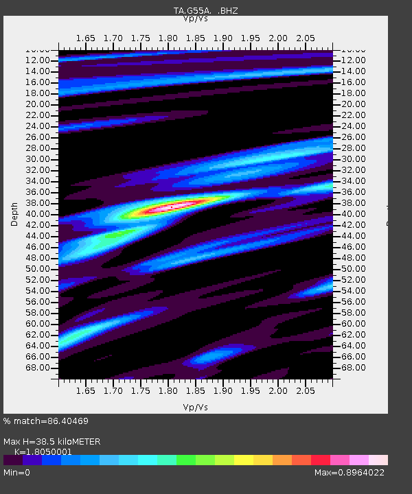
| Estimated Moho Depth: |
38.5 km |
| Estimated Crust Vp/Vs: |
1.81 |
| Assumed Crust Vp: |
6.577 km/s |
| Estimated Crust Vs: |
3.644 km/s |
| Estimated Crust Poisson's Ratio: |
0.28 |
|
| Radial Match: |
86.40469 % |
| Radial Bump: |
400 |
| Transverse Match: |
59.99431 % |
| Transverse Bump: |
400 |
| SOD ConfigId: |
626651 |
| Insert Time: |
2014-04-18 23:18:30.421 +0000 |
| GWidth: |
2.5 |
| Max Bumps: |
400 |
| Tol: |
0.001 |
|

Signal To Noise
| Channel | StoN | STA | LTA |
| TA:G55A: :BHZ:20131001T03:48:23.800027Z | 9.8910885 | 3.0637E-6 | 3.0974346E-7 |
| TA:G55A: :BHN:20131001T03:48:23.800027Z | 7.6351905 | 1.15522E-6 | 1.5130206E-7 |
| TA:G55A: :BHE:20131001T03:48:23.800027Z | 2.2158403 | 5.6041387E-7 | 2.5291257E-7 |
| Arrivals |
| Ps | 4.9 SECOND |
| PpPs | 16 SECOND |
| PsPs/PpSs | 21 SECOND |


