You are here: Home > Network List > TA - USArray Transportable Network (new EarthScope stations) Stations List
> Station G62A West of Eustis, ME, USA > Earthquake Result Viewer
G62A West of Eustis, ME, USA - Earthquake Result Viewer
| Earthquake location: |
Sea Of Okhotsk |
| Earthquake latitude/longitude: |
53.2/152.8 |
| Earthquake time(UTC): |
2013/10/01 (274) 03:38:21 GMT |
| Earthquake Depth: |
573 km |
| Earthquake Magnitude: |
6.7 MWW, 6.7 MWC, 6.8 MWC, 6.8 MWB |
| Earthquake Catalog/Contributor: |
NEIC PDE/NEIC COMCAT |
|
| Network: |
TA USArray Transportable Network (new EarthScope stations) |
| Station: |
G62A West of Eustis, ME, USA |
| Lat/Lon: |
45.22 N/70.53 W |
| Elevation: |
426 m |
|
| Distance: |
75.2 deg |
| Az: |
30.104 deg |
| Baz: |
334.727 deg |
| Ray Param: |
0.049989123 |
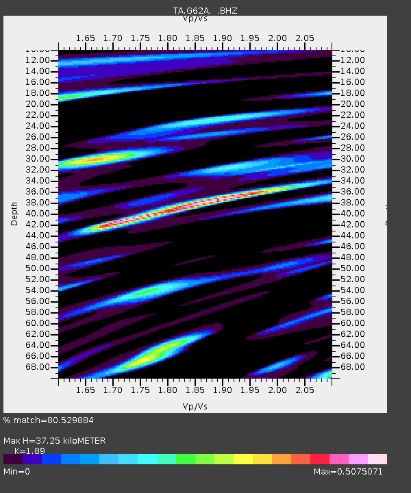
| Estimated Moho Depth: |
37.25 km |
| Estimated Crust Vp/Vs: |
1.89 |
| Assumed Crust Vp: |
6.419 km/s |
| Estimated Crust Vs: |
3.396 km/s |
| Estimated Crust Poisson's Ratio: |
0.31 |
|
| Radial Match: |
80.529884 % |
| Radial Bump: |
400 |
| Transverse Match: |
65.86326 % |
| Transverse Bump: |
400 |
| SOD ConfigId: |
626651 |
| Insert Time: |
2014-04-18 23:18:44.029 +0000 |
| GWidth: |
2.5 |
| Max Bumps: |
400 |
| Tol: |
0.001 |
|

Signal To Noise
| Channel | StoN | STA | LTA |
| TA:G62A: :BHZ:20131001T03:48:35.100015Z | 8.969651 | 3.4262293E-6 | 3.8198024E-7 |
| TA:G62A: :BHN:20131001T03:48:35.100015Z | 4.437145 | 1.4923927E-6 | 3.3634075E-7 |
| TA:G62A: :BHE:20131001T03:48:35.100015Z | 2.5069253 | 5.9621783E-7 | 2.3782833E-7 |
| Arrivals |
| Ps | 5.3 SECOND |
| PpPs | 16 SECOND |
| PsPs/PpSs | 22 SECOND |


